GEOLOGY HAPPENINGS September 2021
|
| Ledgey Sandstones and Colorful Hills: The Morrison Formation Near Moab
By Allyson Mathis |
Last months Geology Happenings presented a big picture overview of the Morrison Formation. Visit the article archive at https://www.moabhappenings.com/Geology.htm
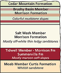 |
| The Morrison Formation near Moab, showing the rock layers above and below it. The Summerville is a separate formation, but is hard to distinguish from the Tidwell Member. The Cedar Mountain Formation looks somewhat like the underlying Brushy Basin Member, but a large unconformity separates the two formations, and the colors in the Cedar Mountain are more muted or pastel in tone.
|
Each of the rock layers (formations to geologists) exposed near Moab has characteristic features that make it recognizable to tourists and residents of southeastern Utah. Here, geology is the bedrock (pun intended) of one of the most scenic landscapes on Earth. But some formations are more iconic than others, and they make up the defining features of canyon country. For example, the Wingate Sandstone makes mile upon mile of towering brick-red cliffs, and the Navajo Sandstone forms off-white rounded slickrock domes that soar throughout the land.
The Morrison Formation near Moab is actually both relatively nondescript and one of the most colorful rock layers found here, depending on what part of the formation is present in a particular area.
The Morrison Formation is found across an area encompassing 1.5 million square miles from New Mexico to Canada and east to Nebraska and the Dakotas. The Morrison was deposited in the latter part of the Jurassic Period between 150-157 million years ago in a continental basin, dominated by rivers and floodplains and bounded by a volcanic highland to the west.
The Morrison is somewhat variable across the large area where it was deposited. Near Moab, it consists of three members. Members are subdivisions of formations, somewhat akin to how chapters are subdivisions of a book. Members are usually defined on the basis of rock type (lithology) , reflecting deposition in specific environments. Members also frequently have a certain geographic distribution within a formation so that members may not be found in the entire area that a formation is.
Two of the Morrisons members are very distinct and readily distinguished from one another and from other rock layers. But the Tidwell Member at the base of the Morrison Formation is not. The Tidwell looks a great deal like the underlying Summerville Formation, even though a significant unconformity (a gap in the geologic record indicating a period of missing time) separates them. In fact, the Summerville and the Tidwell look so much alike that they have been mapped together on some geologic maps, depending on the scale and whether geologists were able to visit outcrops during the mapping process. Both are thin units, dark red to brown in color and consisting of mostly mudstones and siltstones. Large chert concretions are a key marker of the Tidwell Member. Chert (microcrystalline quartz) nodules generally form in soft sediments during diagenesis, the processes that turn sediment into stone.
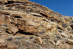
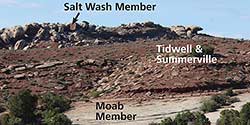 The Salt Wash Member sits above the Tidwell. The Salt Washs off-white pebbly sandstones are distinctive, if not overly scenic. These sandstones were deposited in stream and river channels. The thin beds of the Salt Wash Member contain low-angle cross-bedding that was formed by currents in the ancient rivers. Areas where the Salt Wash is exposed are marked by sandstone ledges and benches that are cross-cut by mining roads since uranium was found in this layer.
Geologists name members after the places where they were first scientifically described the same way that formations are named. This member got its name from Salt Wash in and around Arches National Park. Great places to see the Salt Wash sandstones are along the first part of the Delicate Arch Trail or from the Klondike mountain bike trails.
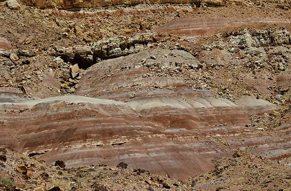
The upper part of the Morrison, Brushy Basin Member, consists mostly of scenic candy-striped slopes made up of mudstones that were deposited on floodplains, but there are a few thin channel sandstones.
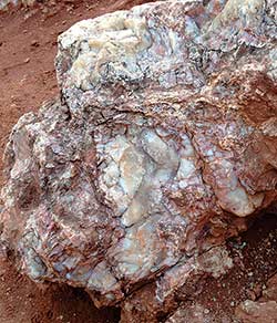 |
| A large chert concretion in the Tidwell Member |
The Brushy Basin is colorful with dark reds, pinks, ochres, tans, and most noticeably greens in some areas like near the Delicate Arch Trailhead. Much of this coloration results from ancient soil horizons, with the green color likely stemming from tiny amounts of iron in a reduced chemical state (versus oxidized red iron). The color of a rock layer doesnt necessarily reflect the environment that it was deposited in, but may result from processes that happen during diagenesis or from groundwater flow.
Another distinctive characteristic of the Brushy Basin is a texture on the surface known as popcorn weathering. Popcorn weathering forms in swelling clays (smectites), also known as bentonite, which is formed from the chemical alteration of volcanic ash. These clays expand when wet and contract as they dry. Repeated cycles of wetting and drying create the frothy or popcorn-like surface.
The Morrison doesnt form large cliffs or slopes where the entire unit is exposed all in one area. As a general rule, either the Salt Wash or the Brushy Basin is exposed at the surface in any one place. The unit has a total thickness of up to a thousand feet near Moab, which means that the Morrison has a lot to lovewhether it is the plain-looking sandstone ledges or the colorful slopes that are pretty as a picture.
 |
 |
 |
| Salt Wash Member |
Brushy Basin Member |
Popcorn weathering. National Park Service photo. |
| |