 |
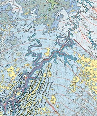
| Part of the Geologic Map of the La Sal 30’ X 60’ Quadrangle, by Hellmut Doelling, showing the Canyonlands area, including the Grabens formed in an area of active faulting in the Needles District. The Cedar Mesa Sandstone (Pcm) is the dominant bedrock unit while Quaternary windblown sand deposits (Qea) cover many areas. The thin red dashed lines are structural contours (imaginary horizontal lines) in 50 meter intervals that show that the regional dip is to the north. Published by the Utah Geological Survey. |
If a picture is worth a thousand words, what is the value of a map?
We all use maps in our daily lives—road maps, trail maps, topographic maps, weather maps, and political maps showing “red states” and “blue states.” A map is a diagrammatic representation, usually in two-dimensions, of an area of land or sea showing physical features, cities, roads, and more.
As is self-evident, a geologic map shows the geology of an area; more specifically, a geologic map shows the distribution of rock units and surficial deposits, such as modern river alluvium (sediment) and eolian (wind-blown) sand, their age and relationships to one another, and the presence of geologic structures, such as faults and folds. Geologic maps often also provide information on mineral deposits, fossil localities, caves, and other features.
 When asked to explain the importance of geologic maps, Grant Willis, Geologic Mapping Program Manager at the Utah Geological Survey said, “I often tell people that a geologic map is the foundation of all geology. It is like the frame of a vehicle. No matter what kind of a car or truck you want to have, it has to be built on a frame. Whether you are a geochemist, paleontologist, student, or weekend geo-hobbyist, a geologic map lies at the foundation of what you are doing.” When asked to explain the importance of geologic maps, Grant Willis, Geologic Mapping Program Manager at the Utah Geological Survey said, “I often tell people that a geologic map is the foundation of all geology. It is like the frame of a vehicle. No matter what kind of a car or truck you want to have, it has to be built on a frame. Whether you are a geochemist, paleontologist, student, or weekend geo-hobbyist, a geologic map lies at the foundation of what you are doing.”
Geologic maps employ a “language” that utilizes colors, different types of lines, and specialized symbols to communicate geologic information. Like for other thematic maps, geologic information is overlain on a base, such as a topographic map or satellite image, in order to portray the subject matter of a geographic area.
Rock layers (formations to geologists) and groups of formations are depicted on geologic maps using different colors with two- to five-letter symbols. Colors are standardized so that geologists know the layers’ general age at first glance: blues for rocks that are Permian (252-299 million years ago) in age, blue-green for Triassic (252-201 mya), green for Jurassic (145-201 mya), and yellow for Quaternary (the last 2.6 million years). The reason that geologic maps of Canyonlands National Park are mostly blue and green is that most exposures are Permian, Triassic, and Jurassic in age. The first letter(s) in the written symbol represents the geologic age, and the lower case letters indicate the formation; e.g., Pwr stands for Permian White Rim Sandstone, TRm for Triassic Moenkopi Formation, and Qal for Quaternary alluvium. The map legend includes these colors and codes as well as descriptions of each rock unit.
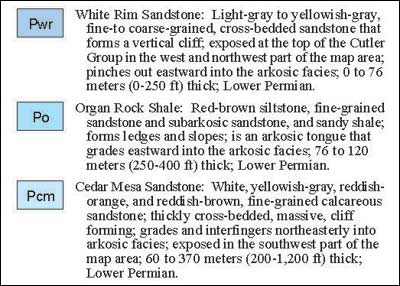 |
| Part of the legend of the La Sal 30’ X 60’ Quadrangle. Some of the formal stratigraphic designations and ages of rock layers have changed since this map was published in 2004. For example, the Organ Rock Shale has been renamed the Organ Rock Formation. Published by the Utah Geological Survey. |
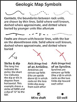
Lines provide a wide array of information. Thin solid lines indicate contacts (boundaries between two rock units) that are well located; the line is dashed to indicate approximate locations, and dotted where buried by younger deposits such as alluvium.
Geologic maps also tell the geologic history of an area by showing how rock units have been deformed (faulted and folded) through time. Heavy lines indicate faults (fractures where rock units have moved relative to one another). Other types of lines indicate folds. The overall orientations of rock layers, i.e. their tilt off of horizontal, are indicated by strike and dip symbols. On the regional scale, rock layers in southeastern Utah are nearly horizontal with very shallow dips, but significant structures such as the Moab-Spanish Valley salt anticline, the San Rafael Swell, and Upheaval Dome have very steep dips in places.
Cross-sections that usually accompany geologic maps provide further information about the three-dimensional orientation of rock units by showing their third dimension —their projection below the surface.
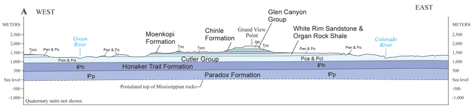 |
| Part of an east-west cross section showing the Canyonlands area from the La Sal 30’ X 60’ Quadrangle, modified with additional labels for the rock units. Here, the Glen Canyon Group is the Wingate Sandstone, Kayenta Formation, and Navajo Sandstone. Published by the Utah Geological Survey. |
 Geologic maps are of interest to more than just scientists. They have a myriad of applications in land use planning, transportation, water development, energy and mineral development, national defense, outdoor recreation, and even public health. Geologic maps are also important in planning for the evaluation and mitigation of geologic hazards such as earthquakes, volcanic eruptions, landslides, and avalanches. Geologic maps are of interest to more than just scientists. They have a myriad of applications in land use planning, transportation, water development, energy and mineral development, national defense, outdoor recreation, and even public health. Geologic maps are also important in planning for the evaluation and mitigation of geologic hazards such as earthquakes, volcanic eruptions, landslides, and avalanches.
Geologic maps are so important to the field of geology—and by extension to human society—that they could even be described as “bedrock” (pun intended).
Special thanks to Grant Willis, Utah Geological Survey.
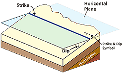 |
| Strike and dip measurements show how rock layers have been deformed from their original horizontal orientation. Strike is the direction of a line formed by the intersection of a horizontal plane with a tilted rock layer, and dip is angle of a tilted layer compared to the horizontal, with a maximum of 90° for beds that are vertical. |
|