GEOLOGY HAPPENINGS September 2020 |
||||||
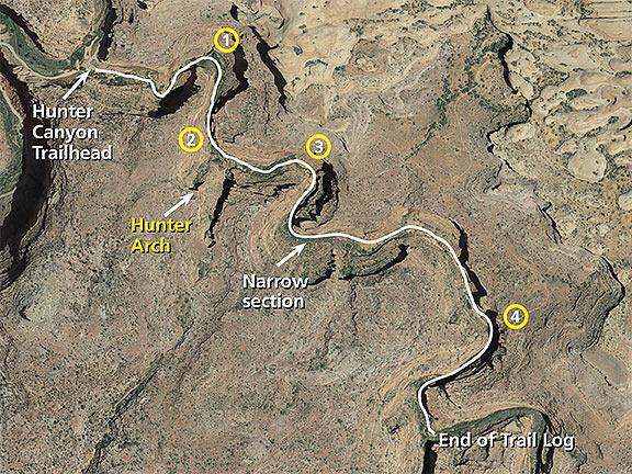
| Geo-Hiking Moab: Trailside Geology of the Hunter Canyon Trailby Allyson Mathis | ||||||
Hiking Moab area trails is one of the best ways to experience canyon country geology. This is one of a series of periodic columns on trailside geology. Mileages for trail logs are measured using a handheld GPS unit; please be aware that distances measured in this narrow canyon are not as accurate as distances measured in locations with better GPS coverage.
The Hunter Canyon Trail is an easy and relatively peaceful hike near Moab. The trail follows a spring-fed drainage with lush riparian vegetation and has beautiful red rock scenery. It passes below Hunter Arch, a large opening near the canyon rim. The route follows the canyon bottom so the trail is indistinct in places as it crosses the stream time and again. The walls of Hunter Canyon are made up of the Wingate Sandstone capped by the Kayenta Formation, with the contact, or boundary, between them being hard to identify. Both consist of reddish brown sandstones that comprise most of the prominent cliffs near Moab. The Wingate Sandstone was deposited in an eolian (sand dune) environment, and the Kayenta Formation was deposited by sandy-bottomed rivers.
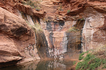
In additional to providing opportunities to enjoy picturesque canyon walls and a spectacular natural arch, Hunter Canyon is a great place to observe a number of small springs and seeps, many of which form hanging gardens on the canyon walls. Trail Log Mile 0.0 Trailhead is adjacent to the fee sign for the BLM campground. The trail crosses the creek for the first time just ahead. During dry periods, the stream can be nearly dry; otherwise getting across the creek may require rock hopping. Location 1 (0.3 Mile): The first of the many seeps that can be seen in Hunter Canyon is on the left (north) side of the creek. Seeps are small springs with minimal flow where sometimes the amount of water present can’t do more than wet the rock surface. But water flows from this seep at times into the pool below. Springs emerging on vertical cliff faces are known as hanging gardens because they are generally adorned with vegetation growing on vertical or overhanging surfaces. Water only emerges from bedrock under the right geologic conditions. Here, an impermeable lens in the otherwise porous sandstone causes groundwater to flow laterally until it emerges at the cliff face.
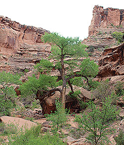
Just past the overhang, look to the canyon rim at the above right for a view of Hunter Arch. Location 2 (0.5 Mile): A large boulder from a rock fall is in the middle of the drainage here. It is not possible to know when the rock fall occurred, but it obviously happened before the large cottonwood tree grew around it. Most cottonwoods do not live for more than a hundred years, and many live for much less. But the rock fall occurred long enough ago so that it is not possible to determine exactly where on the cliff face from which it fell. Hunter Arch is visible on the canyon rim high and to the right from this spot and from the next short section of trail. Location 3 (0.7 Mile): A large alcove is to the left of the stream. The quantity of rubble below alcove shows that has been enlarged by rock falls. Like other alcoves in Hunter Canyon, it probably began as a small seep on the canyon wall. Mile 0.9: The route through the canyon here is usually narrow in this area due to heavy riparian vegetation, depending on current conditions in the canyon. Some hikers may decide to turn around here because of the overgrown vegetation. 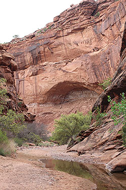 Mile 1.1: Several hanging gardens are located high on the canyon wall to the left. The white staining is from deposits of calcium carbonate and other minerals that precipitated out of the spring water, and the black coloration is most likely from deposits of organic material. Location 4 (1.3 Mile): Another area with a number of large alcoves on the left (north) side of the canyon near where it takes a sharp turn to the south/southwest. Rock falls have also enlarged these alcoves. Erosion here has also been aided by joints (fractures) parallel to the cliff face. The roof of the most upstream of the large alcoves curves like an arch. Such a natural curve dissipate the force outward greatly thereby strengthening the form. 1.7 Mile: Junction with large side canyon on the right. End of trail log. 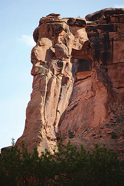 |
||||||
|