GEOLOGY HAPPENINGS July 2020 |
||||||||
| The Cedar Mountain Formation: Scientific Significance Instead of Scenic Splendorby Allyson Mathis | ||||||||
|
Rock layers (formations to geologists) can be important in a number of different ways. Near Moab, the scenic qualities of a rock layer seemingly reigns supreme. Many people consider the most significant rock layers to be the ones that play the most prominent roles in the iconic scenery of the canyon country landscape.
Other rock layers have value in other ways, sometimes literally in the case of ones that have economic significance. For example, the Paradox Formation contains potash deposits that are mined south of Moab, and uranium ores were mined from the Chinle and Morrison formations. Yet other layers are critical because of their scientific significance. The Cedar Mountain Formation is one such layer. While the Cedar Mountain Formation wasn’t scientifically named until 1944, active research into the unit and its dinosaur fossils has provided important new information on dinosaurian diversity and evolution in western North America during the early Cretaceous. Overall, the Cedar Mountain isn’t as heralded among the general public as the better-known Morrison Formation, but its dinosaur fossils are just as important as those from the Morrison, if not even more so, especially since more species of dinosaurs are known from the Cedar Mountain than from the Morrison.
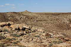
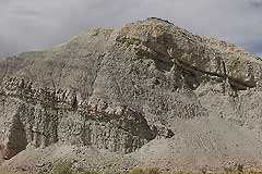
Much of the Cedar Mountain is rather drab in color without much to make it stand out as far as scenery goes, especially compared to the otherwise brilliant red-to-orange rocks exposed near Moab. It is generally colored a pale olive-green to tan and buff, and consists mostly of mudstones that weather to low hills with a few ledge-forming sandstones. By definition, the Cedar Mountain is only found on the west side of the Colorado River, with the mostly-equivalent Burro Canyon Formation found east of the river. The Cedar Mountain was deposited on a broad floodplain by rivers that flowed mostly from the southwest shifting to west with onset of mountain building in western Utah. The unit gets its name from Cedar Mountain in the San Rafael Swell where it was first described.
The Cedar Mountain Formation is not very thick, only ranging up to 250 feet thick in southeastern Utah, but it spans a large time interval (from approximately 140 to 100 million years ago in the early Cretaceous Period), which is as great or greater than that of any of the other rock layers found near Moab. Additionally, rocks of the same age are relatively rare in western North America, increasing the Cedar Mountain’s importance in the geologic and fossil record.
Overall, the Cedar Mountain contains six distinct dinosaur faunas divided by unconformities within the unit that reveal a previously unknown mass extinction when dinosaurs like Utahraptor, Moabosaurus, and Gastonia, went extinct approximately 120 Ma. During the next 20 million years North America was an island continent with endemic dinosaurs, primitive sauropods, smaller raptors, and armored dinosaurs. The uppermost Cedar Mountain Formation is only preserved on the west side of the San Rafael Swell. Over 100 species of fish, frog, lizard, dinosaur, mammal, etc. and dinosaur nests have been recovered from this last two million years of deposition of the Cedar Mountain Formation. The Mill Canyon Tracksite northwest of Moab with its interpretive trail is also in the Cedar Mountain. Tracks of eight different types of dinosaurs may be viewed from the boardwalk, along with tracks from birds, turtle, and crocodiles, making the Mill Canyon site one of the most diverse and significant tracksites from the early Cretaceous in the world. Hopefully, this column promotes a wider appreciation for the Cedar Mountain Formation. While most folks may not purposely set out to spend time in the Cedar Mountain Formation just for its scenery, it is rich in scientific significance, leaving scenic splendor to other rock layers found near Moab. Special thanks to Jim Kirkland, Utah State Paleontologist, and ReBecca Hunt-Foster. |
||||||||
|