GEOLOGY HAPPENINGS June 2020 |
||||||||||
| Moab’s Geoheritage: More Than Just A Lot of Pretty Rocksby Allyson Mathis | ||||||||||
Moab has a lot to offer the geologist and nongeologist alike, as well to the mountain biker, rock climber, jeeper, history buff, and tourist enjoying the parks during a family vacation. Geology plays an essential role in nearly every person’s experience in southern Utah since Moab’s red rocks set the scene for countless photographs, determines the routes of trails and roads, and even impacts what species of wildflowers may adorn a particular viewpoint or roadside. Moab also has great value to geology researchers and students, contains an important fossil record, especially of dinosaurs, and has provided critical minerals to the nation, both historically and currently. In short, Moab has a rich geoheritage. Geoheritage is the one term that can encompass all the different ways that geology is important to everyone in southeastern Utah and how it is truly a part of Moab’s endowment. There are a handful of definitions of geoheritage and all it encompasses, but the definition used by the National Park Service provides a good encapsulation of the concept. Geologic heritage encompasses the significant geologic features, landforms, and landscapes characteristic of our Nation which are preserved for the full range of values that society places on them, including scientific, aesthetic, cultural, ecosystem, educational, recreational, tourism, and other values. Geologic heritage sites are conserved so that their lessons and beauty will remain as a legacy for future generations.
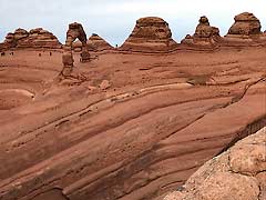
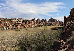
A region’s geologic heritage includes formally-protected sites such as national and state parks, as well as recreation sites (like Canyon Rims Recreation Area), national forests, and areas without a particular conservation designation. Fisher Towers, Corona Arch, Mill Canyon Tracksite and Dinosaur Trail, Hidden Valley, Sand Flats, and Onion Creek, are all part of Moab’s geoheritage. Nationwide, many national parks were established, at least in part if not primarily, because of geology, including Moab’s Arches and Canyonlands. Arches was first set aside in 1929 for its “extraordinary examples … of gigantic arches, natural bridges, ‘windows,’ spires, balanced rocks, and other unique … sandstone formations.” The purpose of Canyonlands National Park is to preserve its striking geologic landscapes and associated ecosystems. The scenic splendor of Arches, Canyonlands, and Dead Horse Point State Park is a major facet of these parks’ appeal, and the scenery is nearly all geology. One benefit of the Colorado Plateau’s dry climate is that the landscape is dominated by exposed bedrock, and not by what a geologist may describe as “green fuzzy things” (e.g., trees and other vegetation). Further, southeastern Utah’s canyon country is blessed with rock layers that are inherently visually attractive, such as the orange-red Entrada Sandstone that erodes into domes, arches and other curved forms.
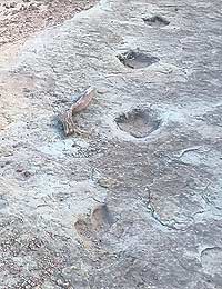
Moab’s geologic landscapes not only have inspirational qualities, but they also possess great scientific value. Some of the geologic research that occurs around Moab is like that which occurs in any region: efforts to understand the area’s geologic history, mineral resources, and geologic hazards. But a few subjects receive international attention. For example, the thick salt deposits in the Paradox Formation that are found underneath southeastern Utah draws researchers and students to Moab from all around the world. Some of the unique features related to these salt deposits, such as the Grabens in Canyonlands National Park and the Moab-Spanish Valley salt anticline, help geologists understand how salt behaves when it flows plastically due to the weight of overlying sediments. The Grabens are a series of parallel troughs with flat floors and vertical walls that formed from underground salt flowage towards Cataract Canyon. Moab-Spanish Valley is not a river valley, but formed after the collapse of an anticline (a type of fold where the rock layers are domed up) due to salt dissolution by groundwater. Moab’s fossil record is also superlative. Type specimens of Gastonia, a type of armored dinosaur and Moabosaurus, a sauropod, were found near Moab. Moab also contains some of the most extensive and scientifically significant dinosaur trackways in North America.
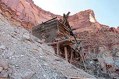
The history of mining and mineral exploration is also an important part of Moab’s geoheritage. The uranium boom during the 1950s was a mineral created and promoted by the federal government with a guaranteed price and bonuses for new discovers in the effort to ensure a domestic supply of this critical element. Exploration for uranium deposits led to the grading of many of the off-road trails enjoyed by 4-wheelers today.
Solution mining of potash (potassium chloride), which is found along with ordinary salt in the Paradox Formation, is another important part of Moab’s geologic heritage and has been ongoing for nearly 50 years, providing both an important commodity to the nation and contributing to Moab’s economy. In general, heritage is something of value that is passed down from generation to generation. Southeastern Utah’s greater landscape contains many cultural, ecological, and scientific values that make Moab Moab. Yet at its core, geology is such an inherent part of Moab’s overall heritage that the prefix “geo” could be placed in front of nearly every word that is associated with what makes Moab stand out from most other small towns in the country. It turns out that Moab’s main attractions may be the geo, as in geo-tourism, geo-mountain biking, geo-jeeping, geo-photography, and geo-climbing. |
||||||||||
|