 |
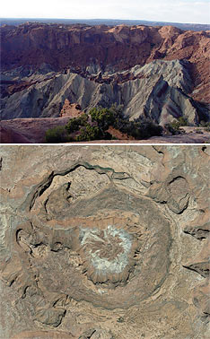
| Upheaval Dome is a good example of a geologic feature where satellite imagery provides a more comprehensive perspective than the view from the ground. Top USGS photo. Bottom Imagery from Google Earth. |
As I write this column in late April, Utah is still under the governor’s “Stay Home, Stay Safe” directive, and Moab, along with the rest of Grand, Emery and Carbon counties, is under a Public Health Order that has closed overnight lodging (including camping) and implemented other restrictions in response to the Covid-19 pandemic. Arches and Canyonlands national parks are also closed as a precaution. These measures are to limit the spread of coronavirus, to ensure that the region’s healthcare system doesn’t become overwhelmed, and to protect our health.
The restrictions on nonessential travel make the spectacular geology of canyon country far less accessible than usual. While it is appropriate for residents to enjoy outdoor activities in their local area (while maintaining social distancing and taking extra precautions to stay safe), this is a good time for us to become armchair geologists who experience the Moab area’s landscapes and geologic stories vicariously.
The coronavirus crisis has inverted the geologic maxim, “the best geologists are those who have seen the most geology in the field.” For the time being at least, the best way to explore southeastern Utah’s geology is by staying home and reading geology books or utilizing online resources that provide information on Utah’s geology.
The Geology Happenings archive www.moabhappenings.com/Archives/
000archiveindex.htm#GeologyHappenings is a good place to start any digital adventure traversing through Moab’s geology. It contains articles on topics ranging from fossils to current research on the evolution to Moab’s youthful landscape. I’ve written 28 columns to date and these essays one day hopefully will be collected into a book. (My writing goal is not the Great American Novel, but merely the Great Moab Geology Book, although I must admit that haven’t even made any progress during these recent weeks with all the extra at home time).
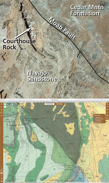 |
| The Moab Fault near Courthouse Rock. It is easy to map the trace of the Moab Fault using Google Earth here because of the difference in color between the Cedar Mountain Formation and the other rock layers in the area. Imagery from Google Earth. The screen capture is of the Utah Geological Survey’s Geologic Map Portal. |
While you are online, you may want to make time to further explore the Moab Happenings archive at www.moabhappenings.com. Complete issues from the last 10 years are available for download, in addition to articles from current and past regular columns including Nature Happenings, Science Happenings, and Historic Happenings. Nature Happenings by Damian Fagan is the longest running series in Moab Happenings history and is now in its twentieth year.
The larger virtual world available on the internet also avails armchair geologists with a wide range of information. The Utah Geological Survey’s website geology.utah.gov is probably the single best online resource for Utah geology and it contains material targeted at general audiences and teachers to geoscience professionals. One popular feature is GeoSights geology.utah.gov/apps/geosights/index.htm, a series of articles on some of the lesser-known geologic locales including Wall Arch, Onion Creek, and Fisher Towers. The article archive for Survey Notes, the survey’s nontechnical magazine, is also a great resource geology.utah.gov/map-pub/survey-notes/.
My favorite part of the UGS website is the interactive geologic map available from the Geologic Map Portal geology.utah.gov/apps/intgeomap/. Geologic maps depict what rock layers (formations) are present at the earth’s surface in an area along with geologic structures like faults and folds. The Geologic Map Portal allows users to zoom in and out, choose from three different base maps (topographic, terrain, and satellite), obtain detailed descriptions of rock units, and download map PDFs. Like many geologists, I still love paper maps, but find the portal an invaluable resource when conducting research for Geology Happenings.
Google Earth and/or Google Maps (using the satellite view) are other essential tools that I use when drafting my columns, sometimes in conjunction with the interactive geologic map. Aerial photographs have traditionally been used by geologists to assist in geologic mapping, especially for gaining a “bird’s eye view” of large geologic features. Google Earth and Google Maps make satellite imagery readily available, allowing anyone to photointerpret the geology of southeastern Utah. For example, I’ve used Google Earth to follow the trace of the Moab Fault (April 2020), to map the geology along the Delicate Arch Trail (March 2019), and to gain a larger perspective of the Grabens (June 2018). 
Books are also excellent means through which armchair geologists can learn more about the geology of southeastern Utah, whether they are revisiting a classic (such as the Exploration of the Colorado River and its Canyons by John Wesley Powell), consulting a more technical book like the Geological Evolution of the Colorado Plateau of Eastern Utah and Western Colorado, or reading a popular book such as Geology Unfolded. Both Back of Beyond Books and the Grand County Public Library are currently providing curbside book service in Moab making these geologic stories available.
Everyone has had their lives upended in ways large and small due to the Covid-19 pandemic, and some of us may become sick ourselves or lose friends or loved ones to the disease. Many (maybe most) people who live in or travel to southern Utah experience the beauty of landscape around Moab as a balm for a troubled heart or mind, and a refuge from worry. Perhaps using online resources and reading geology books while we are stay-at-home armchair geologists will make the wait a little easier until the parks and campgrounds are open again, and once more we have sandstone and slickrock under our boots or wheels.
|