 |
| |
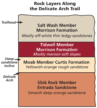
Simplified chart of rock layers (formations) seen along the Delicate Arch Trail. |
Hiking Moab area trails is one of the best ways to experience canyon country geology. This is one of a series of periodic columns on trailside geology. Columns include a brief overview of the area’s geology and a trail log organized by mileage (starting at 0.0 miles at the trailhead) with distances determined using a handheld GPS
| Delicate Arch Trail: 1.6 mile one-way from the Delicate Arch Trailhead in Arches National Park. Elevation gain is approximately 550 feet. Although this trail is just over three miles round trip, it is harder than the mileage suggests. The hike is mostly uphill to the arch, including a steep climb up slickrock with no shade. Hikers should carry water, snacks, and other essentials, and in the summer, not hike during middle of the day. |
When most hikers set out from the Delicate Arch Trailhead, their single-minded goal is reaching Delicate Arch. The arch itself isn’t visible until the very end when a rock wall adjacent to the trail gives way, and Delicate Arch appears, framing the La Sal Mountains in the distance. Delicate Arch is truly one of the most incredible sights found in any national park, and is a destination very much worth the hike. But the Delicate Arch Trail offers many other geologic pleasures along the way, and hence both the journey and the destination deserve our attention.
Delicate Arch is located on the north side of the Salt Valley anticline, where the rock layers have been folded up because of subterranean movement (upward bulging) of underground salt. Faults (surfaces along which blocks of the earth’s crust have moved relative to one another) formed when the salt was dissolved by groundwater, causing the anticline to collapse. Several faults run approximately east-west through the area.
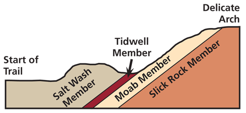 |
| Generalized diagram showing the topography and geology along the Delicate Arch Trail.
Not to scale and with vertical exaggeration. |
Because the rock layers in the area are generally tilted upwards from the trailhead towards Delicate Arch, the trail passes through progressively older rock layers although it ascends in elevation. The trailhead is in the Morrison Formation and Delicate Arch is at the contact between the Entrada Sandstone and the Curtis Formation.ements gave rise to the Moab-Spanish Valley area.
Trail Log
Mile 0.0 Trailhead: From here the trail travels approximately 500 feet to a bridge over Salt Wash. In this first section, the trail itself is on recent stream deposits. Nearby rock outcrops are in the Morrison Formation.
The Morrison Formation was deposited in river and floodplain environments during the Late Jurassic Period, approximately 150 million years ago. During this hike, we will differentiate between two members of the Morrison because they are so visually distinct, and will identify members of the other rock layers seen along the trail for the same reason. Members are subunits of rock layers (formations), much like chapters are parts of books.
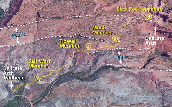 |
| Map of the Delicate Arch Trail. Imagery is from Google Earth. |
 |
| Figure 1 |
Location 1 (0.2 Mile): Start of a short switch back in the Salt Wash Member of the Morrison Formaton. The Salt Wash Member consists of off-white thin ledgey sandstones that were deposited in stream channels interspersed with layers deposited in floodplains. Pebbles, petrified wood, and sometimes dinosaur bone fragments are present in these channel sandstones. The sandstones are more resistant to erosion than the siltstones deposited along with them, so areas where the Salt Wash is exposed are characterized by these blocks of white sandstone.
A little past the top of the rise and before a short descent ahead, hikers can get a good overview of much of the rest of the trail (Figure 1). The Salt Wash Member is in the foreground, the maroon and light-colored slopes of the Tidwell Member of the Morrison Formation are in the middle distance, and the steep slickrock incline beyond is in the Moab Member of the Curtis Formation.
 |
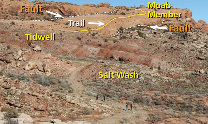
| Figure 2 |
0.6 Mile: The trail now passes through the Tidwell Member. The Tidwell was deposited in floodplain closer to the shoreline of an ancient ocean. As the Tidwell mostly consists of maroon and light colored slopes of soft siltstone, the most prominent features of the Tidwell are large nodules of chert or silica that can be several feet in diameter. Several of these concretions can be seen near the trail. (Please note that it is not permissible to collect rocks in a national park.)
Location 2 (0.8 Mile): The trail leaves the red slopes of the Tidwell Member here and begins its ascent up bare sandstone in the Moab Member. Prior to its reclassification to the Curtis Formation, this member was part of the Entrada Sandstone (see the December 2018 issue of Geology Happenings. The Moab Happenings archive is found online at
https://www.moabhappenings.com/Archives/000archiveindex.htm). One of the reasons why these two sandstones were separated into two different rock layers is because there is a surface of erosion (called an uncomformity) between them. This uncomformity is very subtle near Delicate Arch, but is more evident elsewhere.
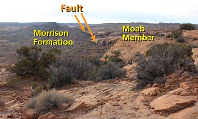
Location 3 (1.1 Mile): The trail crosses a small drainage that follows the trace of a fault. There is not much displacement across the fault where it crosses the trail, but it is visible to the right (west) where the Morrison Formation has dropped down and now abuts against the Moab Member (Figure 2).
1.3 Mile: The trail is now in the Slick Rock Member of the Entrada Sandstone for the first time. The differences in the visual appearances between the Moab Member and the Slick Rock Member are not pronounced, but the two units can be discerned with practice. The Moab Tongue is slightly more yellow in color and has rougher surfaces that can be ledgey. The Slick Rock Member is a deeper orange with smooth surfaces that sometimes have small spherical holes
 |
| Figure 3 |
in them. One of the reasons that the two rock layers look so much alike is that they are both eolian (wind-deposited) sandstones formed in large sand dunes, although at slightly different times.
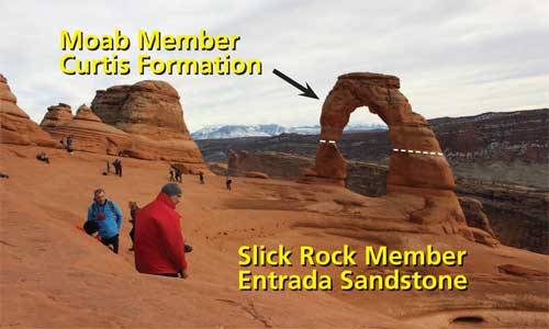
Location 4 (1.6 Mile): The trail ends at the view of Delicate Arch, although hikers can walk the short distance to stand directly underneath the 60-foot tall arch. Delicate Arch is commonly described as being entirely in the Entrada Sandstone, but the reclassification of the Moab Member out of the Entrada Sandstone changed that. The upper part of the arch is in the Curtis, and the lower portion is in the Entrada (Figure 3). The contact, or boundary, between the two layers is approximately at the thinnest section of the uprights.