| Geology HAPPENINGS December 2018 | |||||
Simply Slick Rock: Getting to Know Moab’s Entrada Sandstone |
|||||
The Entrada Sandstone is one of the most important rock layers in the Moab area. Because of its starring role in the scenery of Arches National Park, the Entrada Sandstone is easily one of the best-known rock layers in Utah. Other important local landmarks, such as Monitor and Merrimac Buttes and Wilson Arch, are also made out of the Entrada Sandstone. Despite the prominence of the Entrada in the local landscape, there are a number of complexities to the Entrada Sandstone that make its entire geologic story difficult to know.
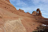
Near Moab, the Entrada is a pale reddish-orange sandstone that erodes into rounded slickrock domes, fins, mesas and spires. Its smooth slickrock surfaces are characteristic of the unit, not only for their subtle color banding, but also for the small spherical holes that appear to trace some of the layering. In Arches National Park, the Entrada Sandstone is between 200 and 500 feet thick and hosts to the largest concentration of natural stone arches in the world. The Entrada Sandstone was deposited approximately 160 million years ago in an erg, or “sand sea;” a.k.a., a large desert sand dune complex. The Entrada erg lay just east of an arm of an interior seaway and was centered on what is now southeastern Utah and the adjacent Four Corners states. Rock layers such as the Entrada are described as being eolian in origin, with the etymology of the word being from Aeolus, the Greek God who was the keeper of the winds. Eolian deposits contain sand grains that were transported and deposited by the wind rather than by water. Modern ergs include parts of the Sahara and the deserts in Australia.
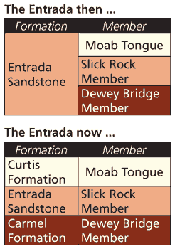
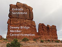
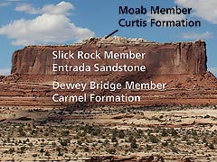
As is the case for other rock layers around Moab, such as the Wingate Sandstone or the Moenkopi Formation, the Entrada Sandstone was named and classified according to geologic standards. Geologic nomenclature adheres to a set of rules, much like the ones for binominal “Latin” names for plants and animals. The Entrada Sandstone is classified as a formation, which is the fundamental unit in the geologic system of naming. (To learn more about how formations are named, please refer to the February 2018 Geology Happenings column in the Moab Happenings online archive.) If the earth’s rock layers are like a library containing the planet’s history through geologic time, then formations are the books telling the stories of certain times and places. Formations are sometimes divided into subunits called members, like some books are divided into chapters. Many people who have been around Moab for a while originally learned that the Entrada Sandstone consisted of three members: The Dewey Bridge Member, the Slick Rock Member and the Moab Member, or “Tongue.” The Dewey Bridge is made up of contorted or wavy thin maroon-brown layers beneath the Slick Rock Member. Slickrock is a term used on the Colorado Plateau to describe any bare, exposed surface of sandstone regardless the rock layer. For example, large areas of slickrock in southeastern Utah are also formed by the Cedar Mesa and the Navajo Sandstones. As a formal geologic name, the Slick Rock Member is only in the Entrada. The Moab Member sits on top of the Slick Rock Member. It is also a sandstone but is off-white or tan in color and not as thick as the Slick Rock unit, but otherwise looks similar as it was also deposited by wind in an ancient erg.
These three members were defined as part of the Entrada Sandstone in the 1960s by geologists who classified the rock units in southern Utah. However, continued research by Hellmut Doelling and other geologists who studied the geology in Arches and throughout southeastern Utah has shown that the Dewey Bridge Member and the Moab Member actually belong to other “books;” e.g., to the rock layers found immediately below and above the Entrada. Geologic mapping along with careful tracing and correlation of the rock layers around Moab and in the San Rafael Swell has shown that the Dewey Bridge properly belongs to the Carmel Formation, which is slightly older than the Entrada Sandstone and sits immediately below it and was deposited mostly in tidal flats. And the Moab Tongue can be traced into the Curtis Formation, which sits above the Entrada in the San Rafael Swell. With the reassignment of the Dewey Bridge and Moab Members in 2000, the Entrada Sandstone around Moab contains only one member, the Slick Rock.
This revision to the nomenclature of the Entrada Sandstone is just one of the complexities that relates to this rock layer. Next month, Geology Happenings will explore the reasons why the Entrada Sandstone looks so elsewhere in southern Utah, such as in Goblin Valley State Park and Capitol Reef National Park. The Entrada seems like an easy rock layer to get to know. Anyone who has walked the trails in Devils Garden, up to Delicate Arch or in the Windows has a picture of the Entrada Sandstone in their mind’s eye. While the story of the Entrada Sandstone boils down to simply slick rock around Moab, this geologic book also tells tales of hoodoos and cathedrals elsewhere in Utah.
|
|||||
|
|||||