Getting out on the trails around Moab is one of the best ways to enjoy and experience canyon country geology. This is the first of a series of periodic columns that will highlight the geologic features that can be seen along Moab area trails. Columns will include a brief overview of the area’s geology and then a trail log organized by mileage (starting at 0.0 miles at the trailhead) with distances measured using a handheld GPS.
Hidden Valley Trail: 3.1 mile one-way from Hidden Valley Trailhead to the eastern terminus of the Moab Rim 4-wheel-drive route. Elevation gain is approximately 680 feet. This trail has great shade in the late afternoon during the summer. Hikers should carry a map, water, snacks, a first aid kit and other essentials.
To reach the trailhead, travel 3 miles south of Moab on Highway 191, and turn right on Angel Rock Road. Then turn right on Rimrock Road and follow it to the trailhead and gravel parking lot. |
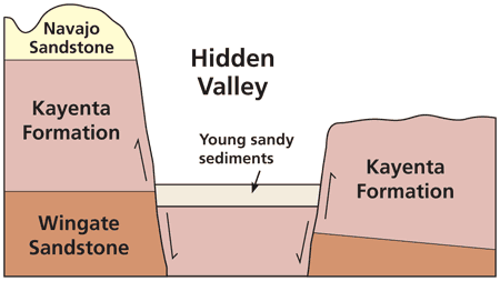
Hidden Valley is one of those places around Moab that is unexpected, that someone heading out from a trailhead wouldn’t expect. From the trailhead, a hiker can see the cliffs that rise above Moab, but there isn’t even a hint of the small, elongated basin found above the switchbacks. Hidden Valley itself looks like a valley, but with one vertical rock wall rising higher than the other. However, the name “Hidden Valley” is a geologic misnomer. While it may be hidden from Moab below, it is not technically a valley. By definition, valleys are formed from the fluvial action of running water, but no drainage system feeds into or out of Hidden Valley. Therefore, it must have formed in another manner.
Like the Grabens in the Needles District of Canyonlands National Park (see the June issue of Geology Happenings to learn about the Grabens. The Moab Happenings archive is found online at
https://www.moabhappenings.com/Archives/000archiveindex.htm), Hidden Valley is a graben, or a down-dropped block between two faults. (Faults are surfaces along which blocks of the earth’s crust have moved relative to one another.) This graben formed as part of the complex faulting that formed the Moab Valley. Both the Moab Valley and Hidden Valley are ultimately tectonic in origin, meaning that they formed from movement along faults. Smaller faults such as those that bound Hidden Valley are not uncommon in the vicinity of larger faults such as the ones whose movements gave rise to the Moab-Spanish Valley area.
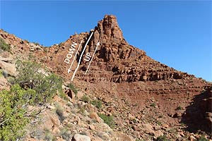 |
| Figure 1. View of one of the faults that formed Hidden Valley taken from the trail. |
Trail Log
Mile 0.0 Trailhead: From here the trail leads to the base of the cliffs, then switchbacks up the talus slopes below cliffs of Wingate Sandstone and Kayenta Formation that hold up the Moab Rim. Talus deposits are made up of broken up rock debris from rock falls that accumulate at the bases of cliffs.
0.4 Mile: The fault that forms the northeast side of Hidden Valley passes underneath the trail in this area. It is covered by talus and is not visible underneath the trail. However, hikers can see this fault if they look towards the northeast toward the rock outcrop (Figure 1).
Location 1 (0.9 Mile): The trail has entered the Hidden Valley graben. Wingate Sandstone cliffs can be seen on both sides of the valley. The nearly-flat floor of Hidden Valley is covered by a thick deposit of young sandy sediments. Grasses (both native species and nonnative cheatgrass) and a few shrubs (such as fourwing saltbrush) grow on these sediments. Junipers and other vegetation are mostly limited to areas of talus, where the soils have more rocks and other coarser sediments.
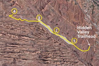 |
| Map of the Hidden Valley Trail. The shaded area shows the approximate area of Hidden Valley. Imagery is from Google Earth. |
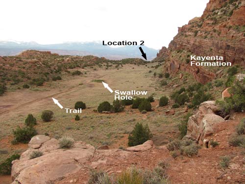
Location 2 (1.5 Mile): The trail crosses a small divide (or narrows) within Hidden Valley. The Kayenta Formation outcrops close to both sides of the trail. The northeastern portion of Hidden Valley ahead is much like the section that the trail has already passed through, and is a good example of an internally-drained basin. The floor of Hidden Valley descends slightly from this divide and rock outcrops rise above the other three sides. The minor washes in Hidden Valley end in “swallow holes” where the drainages just sink and disappear.
2.0 Mile: Swallow holes are present on both sides of the trail in this area. They are visible largely due to different vegetation growing on them, with fewer grasses and more weeds and wildflowers.
Location 3 (2.1 Mile): The end of Hidden Valley (Figure 2). Trail is now on the bedrock of the Kayenta Formation. The trail continues to the northwest with Kayenta Formation exposed on both sides. The Kayenta is dark red in color and consists mostly of small ledges of rock. Vegetation in this next section of trail also reflects this different geology, with juniper and pinyon trees and many small shrubs that favor the thin rocky soils that are most commonly found throughout canyon country.
 |
| Figure 2. Photo looking over Hidden Valley taken near location 3. |
2.7 Mile: The Navajo Sandstone, which is on top of the Kayenta Formation, is now exposed on the left.
Location 4 (3.1 Miles): The trail ends where it joins the Moab Rim four-wheel drive road. The viewpoint at the end of the road gives an excellent overview to the southeast, highlighting the area that the trail passed through after leaving Hidden Valley, with tall domes of Navajo Sandstone all around (Figure 3).
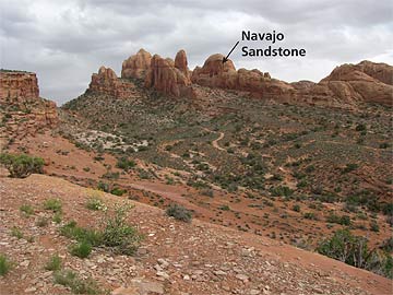 |
| Figure 3. View from near where the Hidden Valley Road meets the Moab Rim jeep road. |
.
.
|