|
|
Trail Happenings January 2012
Nordic Skiing In The La Sal Mountains
by Kirstin Peterson
 Winter is here and the white peaks of the La Sal Mountains present a dramatic backdrop to our red rock desert. When the snow arrives, the small mountain range beckons and people flock to enjoy our own private winter wonderland and all the recreational opportunities that exist just a half hour (or so) from Moab. Whether you prefer skinny or fat skis, telemark or randonee, classic or skating, snowboards or snowshoes, sledding or snowmobiling, there’s something for you in Moab’s upper extremes. Locals and visitors alike are lucky to have groomed trails in the La Sal Mountains which offer access for all kinds of winter recreationists. Winter is here and the white peaks of the La Sal Mountains present a dramatic backdrop to our red rock desert. When the snow arrives, the small mountain range beckons and people flock to enjoy our own private winter wonderland and all the recreational opportunities that exist just a half hour (or so) from Moab. Whether you prefer skinny or fat skis, telemark or randonee, classic or skating, snowboards or snowshoes, sledding or snowmobiling, there’s something for you in Moab’s upper extremes. Locals and visitors alike are lucky to have groomed trails in the La Sal Mountains which offer access for all kinds of winter recreationists.
LUNA (Lower Utah Nordic Alliance) is a group of dedicated volunteers who work with the Manti-La Sal Forest Service to provide a groomed Nordic track system. Beginning in mid-December or whenever the snowpack is established, LUNA volunteers use a system of 2 snowmobiles pulling grooming equipment to lay a Nordic track wide enough for skate skiing and with a set of parallel tracks on the side for classic skiers.
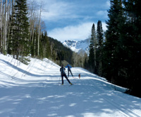
The starting point is the Geyser Pass Road winter trailhead at 9600 ft. and the groomed track goes up from there, where the elevations are higher yet and the air is thin. There are sections of the track that are suitable for all levels of skiers and snowshoe enthusiasts. As you set out from the parking area it is important to know that most of the track is “shared use” and you will see a variety of winter recreationists enjoying the mountains including snowmobilers, backcountry skiers and snowboarders, snowshoe and sledding parties with many canine companions. We ask everyone to please be courteous to other users, move right to allow others to safely pass and keep yourself under control when traveling downhill.
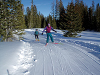 The Meadow Loop is the easiest and closest track to the parking lot. Ski a short way uphill from the trailhead and you’ll see the Meadow Loop take off on the left and wind first through some aspens and then into a beautiful open meadow with Haystack Mountain in the background. The terrain is rolling and the loop rejoins the main track close to where you entered. This .3 mile sunny loop is fun to ski in either direction and is the perfect place to work on your form and get your lungs used to the high elevation. The Meadow Loop is the easiest and closest track to the parking lot. Ski a short way uphill from the trailhead and you’ll see the Meadow Loop take off on the left and wind first through some aspens and then into a beautiful open meadow with Haystack Mountain in the background. The terrain is rolling and the loop rejoins the main track close to where you entered. This .3 mile sunny loop is fun to ski in either direction and is the perfect place to work on your form and get your lungs used to the high elevation.
Gold Basin is an intermediate track and is reached by continuing up the main Geyser Pass Road track from the Meadow Loop to the intersection with the Gold Basin Road, which branches right. The Gold Basin Track is rolling, though more uphill on the return, and offers a peaceful ski through pines and aspens with occasional views of the red rock desert below. You may see backcountry skiers accessing many of the popular runs above the track or returning from turns in the powder. The Gold Basin Track ends at the point where motorized travel is prohibited from going further, thus making this an out and back excursion totaling 8 km (5 miles) round trip from the trailhead.
For the ambitious and fit skier, Geyser Pass and the La Sal Loppet Loop, which branches off at the top of the pass, offer a challenging and beautiful Nordic skiing experience. The Lasaloppet, a fun ski event started by McKay Edwards of Moab Springs Ranch, marked the first true grooming of a big meadow loop off Geyser Pass, hence the name. From the Gold Basin intersection, Geyser Pass is another 2 miles (3.5 km) mostly uphill. Geyser Pass tops out at 10,600 ft and the La Sal Loppet Loop takes off to the right along the road towards Dark Canyon. After approximately .5 miles, the track leaves the main route on the left and winds through open meadows to a point offering wide ranging views of Colorado including the stunning San Miguel and Wilson mountains near Telluride. This rolling loop continues through the trees and emerges on the east side of the Geyser Pass Road where you will take a left up a short hill back to the pass, adding an additional 1.8 miles (3 km) to your distance (8.6 miles/13.2 km total from trailhead). From the pass is it mostly downhill back to the trailhead so be sure to have a warmer wind protective layer for the descent.
Directions to trailhead: From Moab head south on Hwy 191 to the La Sal Mountain Loop Rd turn to the east at the south end of Spanish Valley. Turn right onto the Loop Road, drive about 13 miles to a well marked turn onto Geyser Pass Rd. Drive 3.5 miles to the trailhead. Note that snow tires and/or 4wd are recommended for this road. The road is plowed fairly regularly but call 435-259-7155 or check http://utahavalanchecenter.org/advisory/moab for current conditions and the latest information about road clearing. Be prepared for winter conditions in the mountains and bring appropriate warm clothing, water, and food for any outing into the backcountry. There are no services other than toilet facilities at the trailhead.
About the Author: The Author, Kirstin Peterson is the ski representative for Trail Mix, the Grand County Non Motorized Trails Advisory Committee when she’s not running her mountain bike tour company: Rim Tours. Trail Mix is a contributor to the ski grooming program. If you are interested in volunteering to be one of the ski groomers contact kirstin.m.p@gmail.com.
| The author, Kirstin Peterson, is the co-owner of Rim Mountain Bike Tours and an avid outdoors person. She has been active with Trail Mix and MTA since each organization was first started. |
 Trail Mix This committee represents non motorized trail users including: bikers, hikers, equestrians, and skiers. Many government agencies and private citizens comprise the “mix” that makes this group work so well. We meet the 2nd Tues. of each month from 12-2 at the Grand Center (500W. 182 N.). Everyone is welcome. Trail Mix This committee represents non motorized trail users including: bikers, hikers, equestrians, and skiers. Many government agencies and private citizens comprise the “mix” that makes this group work so well. We meet the 2nd Tues. of each month from 12-2 at the Grand Center (500W. 182 N.). Everyone is welcome.
Contact Sandy Freethey 259-0253 or find us online: wwwgrandcountyutah.net/trailmix/ or at moabtrailmixinfo@gmail.com.
|
|
"Staying Safe Doesn't Have to Mean Staying Home"
Manti-La Sal Avalanche Center |
When the weather in Moab gets cold, freezing the Colorado River and putting snow and ice on everybody’s favorite bike trail or climbing route, there is another alternative available. Find yourself in an inversion? It is time to go and discover the recreation opportunities in the La Sal Mountains. 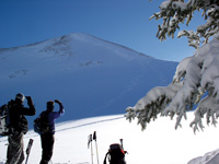
The La Sals are second only to the Uintas as the highest peaks in the state of Utah. These mountains soar to almost 13,000 feet above sea level and over 8,000 feet above the valley floor. A laccolith process formed the La Sals. With this process, a mass of igneous rock intruded between layers of sedimentary rock, resulting in uplift. You could call them frustrated volcanoes too. Aside from the volcanoes of the Pacific-Northwest, there are no peaks with greater rise in the continental U.S.
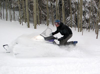
Winter recreation in the La Sals includes cross country skiing, skate skiing, snowshoeing, sledding, back-country skiing and snowmobiling. The winter access to the mountains is provided from two routes kept open by the Grand and San Juan County Road Departments.
1. The La Sal Mountain Loop Road is plowed regularly. The Geyser Pass road is kept open to the restrooms and parking area at 9,600’. The Geyser Pass Road and Gold Basin Road beyond the winter trailhead is a popular area for cross country skiing, snowshoeing and snowmobiling. Groomed trails are provided by the Lower Utah Nordic Alliance (LUNA). Volunteers groom trails approximately twice a week, which provide 12 kilometers of a groomed trail-system, open to every winter user group. These roads also provide access to backcountry skiing and snowboarding in the Mt. Tomasaki and Gold Basin areas. There is a sledding hill just below the parking lot. If you are using the sledding hill, please park in the parking lot so other vehicles can get to the parking lot. The road in the winter is narrow enough!
 Snowmobiles are not allowed to leave the road in Gold Basin. Please respect this closure of the most popular skiing area in the La Sals - the rest of the entire range is open to you! Snowmobiles are not allowed to leave the road in Gold Basin. Please respect this closure of the most popular skiing area in the La Sals - the rest of the entire range is open to you!
2. From near Old La Sal at the south end of the range, the road is plowed regularly two miles short of Dark Canyon Lake, just below Mount Peale. The San Juan Road Department makes a parking lot at about 9,600’.
Winter Huts are available for rent from…
Tag-A-Long Tours: 435-259-8946
These simple cabins are great for folks who want to spend several days in the mountains, but don’t want to lose a couple of hours driving back and forth from town every day. The hut operators can snow cat your supplies and camping gear in for you saving you the heavy carry.
Avalanche Hazard in the La Sal Mountains
The La Sals are rubbly piles of fractured stone. The angle of repose for this broken stone is 38 degrees, and since snow is also a granular substance, 38 degrees is the bulls-eye slope angle for snow avalanches. Keep in mind though, that avalanches run on terrain from 30 - 45 degrees. Most people caught in avalanches are in terrain that is 30 - 35 degrees of steepness. The La Sal Mountains usually possess one of the weakest snow packs imaginable.
For Current Advisories
259-SNOW (7669)
or on the Internet at
http://utahavalanchecenter.org/advisory/moab |
Why do we care? Because 30% of people completely buried by avalanches are killed by trauma and many of those remaining die from suffocation. These are not good odds. It’s not good policy to plan on outrunning an avalanche, even on a fast snowmobile, because avalanches have been clocked at well over 200 mph. Grim statistics showing that snowmobilers are the most likely people to be killed in avalanches also support this.
So what do we do? Fortunately, staying safe doesn’t have to mean staying at home! The good news is that most people trigger the slide that catches them, so if we learn a little about snow and adjust our behavior to suit the conditions, we can continue to enjoy our winter playground!
The Manti-La Sal Avalanche Center in Moab exists to help you make the right decisions. The MLSAC Forecasters examine the snow and produce an advisory informing you of where you are most likely to run into problems and just how sensitive the snow is. They also produce a mountain weather forecast, work with the Moab Winter Search and Rescue Team and provide avalanche education to the community in numerous ways. The MLSAC educates the community through the advisories, classes held periodically, radio announcements on the weekends on KZMU, the website and at the Geyser Pass Trailhead information board. The center director is Max Forgensi.
The website is a great tool for:
• Finding a weather forecast for the Moab area,
including radar images
• A current photo gallery of the La Sal Mountains
• Advisories for the La Sals and the Abajo Mountains
• A current course schedule for southeast Utah
UPCOMING AVALANCE CLASSES
Basic Avalanche Awareness Talk
Friday, January 6th, 2012 at 6:00 pm in the Grand County Library.
AIARE Level 1 Avalanche Course
Friday, February 3rd - Sunday February 5th.
Call to sign up 435-636-3335
You can also find class announcements online at
•http://utahavalanchecenter.org
•http://www.cnha.org/friends/
or by calling 259-SNOW (7669) |
Watch for periodic special events like ski swaps and avalanche awareness classes. If you need to talk to one of the avalanche forecasters, please call 259-7155 Monday-Friday during normal business hours and be sure to mention you read about it in Moab Happenings.
|
|
|
|
|
|
© 2002-2024 Moab Happenings. All rights
reserved.
Reproduction of information contained in this site is
expressly prohibited.
|
|