Trail Happenings August 2009
“On the Trail of Harold Provonsha”
By Max Forgensi
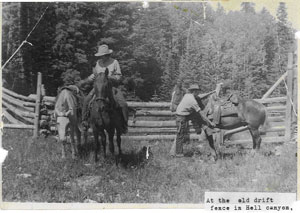 Years before the Manti-La Sal National Forest’s current push to sign and maintain all of these trails, a gentleman named Harold Provonsha roamed the region tending to sheep. Born in 1924, Harold started tending sheep, by himself, at the age of 11 and he continued until 1943. Harold’s mother, Isabelle, would take him supplies on the mountain. His parents kept him out of school during the fall and spring to work in the mountains. Isabelle would take his homework to him every week, and return the assignments to his teachers as he completed them. Harold would write notes on Aspen trees with his name and date, an almost daily occurrence in the early forties, so that his mother would know where he was. When she brought supplies, Harold would run straight for the panniers and find the canned milk. Hundreds of inscriptions remain from Hell Canyon through La Sal Pass to Pole Canyon in what was once known as the “Moores Range.” During the early years of WWII, Harold’s dad obtained a deferral for him from the draft, but when he turned 19, Harold thought he needed to serve his country. He went to the draft board and enlisted in the Navy. An excerpt from an Aspenglygh before he enlisted and after he was in the Navy reads as follows: Years before the Manti-La Sal National Forest’s current push to sign and maintain all of these trails, a gentleman named Harold Provonsha roamed the region tending to sheep. Born in 1924, Harold started tending sheep, by himself, at the age of 11 and he continued until 1943. Harold’s mother, Isabelle, would take him supplies on the mountain. His parents kept him out of school during the fall and spring to work in the mountains. Isabelle would take his homework to him every week, and return the assignments to his teachers as he completed them. Harold would write notes on Aspen trees with his name and date, an almost daily occurrence in the early forties, so that his mother would know where he was. When she brought supplies, Harold would run straight for the panniers and find the canned milk. Hundreds of inscriptions remain from Hell Canyon through La Sal Pass to Pole Canyon in what was once known as the “Moores Range.” During the early years of WWII, Harold’s dad obtained a deferral for him from the draft, but when he turned 19, Harold thought he needed to serve his country. He went to the draft board and enlisted in the Navy. An excerpt from an Aspenglygh before he enlisted and after he was in the Navy reads as follows:
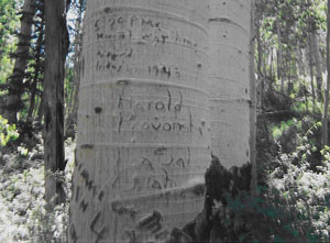 5:20 PM 5:20 PM
Mount Way Home
August
Friday 13, 1943
Harold
Provonsha
La Sal
Utah
SEPT 17, ‘44
To Harold
I’l carve your name on this tree
As you did in ‘43
For your away on acount of war
I will carve for you in 44
MOTHER
The Provonsha family has had a long history in this part of the La Sal’s. Harold’s grandfather had the 1st lumber mill on the La Sal’s. Harold staked prospects near Hell Canyon where his daughter, Anne Oates, worked as a young woman. The Provonsha family also owned the Pack Creek ranch for a spell.
These trails are part of the Manti-La Sal National Forest which contain mountain peaks (12,000 foot elevation), canyons, and forests. These vistas add climatic and scenic contrast to the red-rock landscape surrounding Moab. The area around the South Mountain Trail system is not for the faint of heart. Steep, remote and rugged, one should be prepared for anything. The Hell Canyon Trail itself drops 2400’ in less than 2 miles. Hiking the South Mountain Trail from the east, a person would gain and lose close to 3000’ vertical feet. In 2008, the Forest Service’s trail crew and the Canyon Country Youth Corps (CCYC) started to resurrect the trail system, and they continue this work in 2009. There are still sections that are not completed. The views are very unique. Above Pack Creek and in Bear Park, you can see from the Pack Creek Ranch all the way to the Atlas tailings pile.
When you have a chance to explore this relatively unknown area in your backyard mountains, take the time to enjoy the stillness in the aspen glades. The aged Aspenglyphs are telling a story, of a time that has almost been forgotten.
TRAIL OF THE MONTH:
South Mountain Trail
The South Mountain Trail is the longest non-motorized trail in the La Sal Mountain Range. Starting on the La Sal Pass road across from the Squaw Springs trail, the South Mountain Trail (#029) winds its way for over 10 miles and circumnavigates South Mountain and ends on the east side of the La Sal Pass road below Beaver Lake. The South Mountain Trail intersects the Hell Canyon Trail (039), Pack Creek Trail (041), Pack Creek/South Mountain Trail (075), Pole Canyon Trail (035) and the Doe Canyon Trail (100). It is the southern end of the Trans-La Sal Trail, which starts in Bachelor Basin. Overall, there are over 20 miles of trails for hikers, horseback riders and mountain bikers to enjoy.
Getting there: Drive south from Moab to the La Sal Mountain Loop Road. Leave the Loop Road by turning right at the Pack Creek Road that will take you to the described trails via the La Sal Pass Road. You may also approach South Mountain from the east via the town of La Sal.
Available at the Moab Information Center and elsewhere:
1. National Geographic Manti La Sal Trails Illustrated Map.
2. Manti La Sal National Forest-Moab and Monticello Ranger District map.
3. La Sal Mountain Trail Guide. (A pamphlet with a trail schematic)
Lend a Hand Trail
  Join the local trail groups, Trail Mix and Moab Trails Alliance in the responsible development and maintenance of non-motorized trails. Join the local trail groups, Trail Mix and Moab Trails Alliance in the responsible development and maintenance of non-motorized trails.
VOLUNTEER: “Adopt-A-Trail” - Individuals, businesses or groups may sign up to “Adopt” their favorite trail by volunteering to do light upkeep. Contact Sandy Freethey 259-0253. Trail building, maintenance and restoration - No special skills required. Contact David Olsen 259-5129.
ATTEND a meeting: Trail Mix meets the 2nd Tues of the month at 182 N. 500 W. 12-2:00.
Donate: We have many worthy trail projects that can use your funding. Contact Kim Schappert at 435-260-8197 to donate to the non-profit group, Moab Trails Alliance.
BULLETIN AND WARNING
A word about illegal “user created” bike trails on Forest Service, BLM and National Park lands: Bikers who are caught riding on illegal trails may be fined! The use and promotion of illegal trails jeopardizes the Trail Mix Committee’s ability to create new trails by working within the legal process set forth by the agencies. Get involved, work within the system.
Stay on the Designated Trails! |
|