Summer takes on a whole different meaning in Moab in terms of temperature.
Locals, acclimated to the dry summer heat, also know that if they want to cool off, they go up…up to the La Sals, Abajos, San Juans or the remote Henry Mountains. The temperature can change roughly 3° for every 1,000 feet in elevation gained, making the mountains an appealing spot when the desert is shimmering under 100° heat.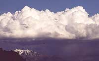
Located adjacent to Moab, the La Sal Mountains were named by early Spanish explorers that roamed the region. “La sal” means “salt” and is in reference to salt deposits located along the mountains’ flank. A prominent landmark along the Old Spanish Trail, a 19th century trade route along which Spanish traders lead caravans of mules laden with goods from Santa Fe, New Mexico to Los Angeles, California. The travelers used this prominent landmark to navigate by before crossing the Colorado River on the north end of the Moab Valley.
Surrounded by the spectacular red rock country comprised of sedimentary rock layers, the La Sals have an igneous core that reminds us the range and region’s limited volcanic history. Unlike the fiery volcanoes of the Cascades, the La Sals are made up of an igneous core that intruded partially into overlying sedimentary layers some 25 to 28 million years ago. This core was later forced upwards during regional uplift, creating the range we see today. 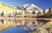
Native Americans inhabited the area for thousands of years before early European explorers entered the region. Some archaeological sites in southern Utah date to over 13,000 years ago, a time when the prehistoric Paleo-Indians hunted big game and harvested plants in the area.
A famous Dominguez-Escalante expedition in 1776 was led by two Franciscan priests in an attempt to explore a route from Santa Fe, New Mexico to Spanish holdings in California. The small expedition didn’t complete their journey, but their travels through the region literally put the La Sals on the map and provided a landmark to guide use along the Old Spanish Trail during its heyday in the 1830s through 1850s.
Fast forward to today.
Many view these peaks as just a backdrop to Arches and Canyonlands National Parks. The snow-capped peaks provide a contrast to the red rock formations, but they too are worthy of summer exploration.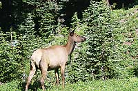
Many of the peaks bare names of past explorers or regional activity. Mt. Peale, the highest point in the range at 12,721’, honors Dr. Albert Peale, the mineralogist on the geologic Hayden Survey of 1875. Mt. Mellenthin, 12,645’, was named after a U.S. Forest Ranger killed in the La Sals during an altercation with a WWI draft dodger.
The mountain slopes are cloaked with aspen, fir, spruce and pine forests. Though cattle roam much of the range in summer, they share these mountains with an abundance of wildlife including elk, deer, bear, cougar, smaller mammals and birds. Wildflowers explode in mountain meadows and invite inspection on mountain summits where green pockets thrive amongst the rocky scree.
From these high peaks one can look down upon the redrock landscape baking in the summer heat, yet feel the cool mountain breezes that have lured many up these slopes over the millennia.