The birds at the backyard feeder scatter like proverbial quail as a blur crosses the yard. Doves and finches, chickadees and sparrows dissolve into the shrubs that line our yard. The blur stops, perches on the fence and gives the bushes the evil eye. I think I hear a sing-song voice saying, “I know you’re in there! Come out, come out wherever you are.”
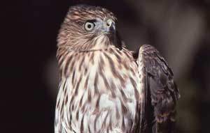 But the little birds know better. The blur, better known as the Cooper’s hawk (Accipiter cooperii), stares for a few more moments, shakes it feathers, then pushes off into the hunting current and disappears. But the little birds know better. The blur, better known as the Cooper’s hawk (Accipiter cooperii), stares for a few more moments, shakes it feathers, then pushes off into the hunting current and disappears.
The crow-sized Cooper’s hawk or “Coop,” as known by many birders, is one of three accipiters found in Canyon Country. Coops are the middle-sized ones, larger than sharp-shinned hawks and smaller than Northern goshawks. Named after William Cooper, a New York naturalist who collected the first specimen for science in 1828, these birds were formerly known as “chicken hawks” after one of their backyard prey items.
Wintering Cooper’s hawks in the Moab area could be either year-round residents or migrants from farther north. The bird’s range extends up into Canada, but many migrate southward in winter, some as far as Mexico or even South America.
When I worked in Arches National Park, I did surveys for nesting Cooper’s hawks. The birds nested in the scant cottonwood galleries than lined Courthouse and Salt Wash. Nest sites were about two miles apart, so I’d spend a portion of the day hiking the wash and checking out the activity. The birds start nesting around April or May, and fledged young in June or July. This breeding season coincided with the horse fly season; it took me one hike of wearing shorts to never repeat that mistake.
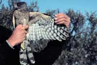 Dressed in pants and a long-sleeved shirt, I’d hike the wash, sweat like Satan, and ignore the flies. I’d locate the hawks by listening for their “mad-laughter” calls or by an adult blasting out of the trees. When I’d locate a bird, I’d stop and scan the trees for nests or adults. The narrow ribbon of vegetation along the wash bottom made it easy to search each tree, as compared to looking for birds in thicker forests. Dressed in pants and a long-sleeved shirt, I’d hike the wash, sweat like Satan, and ignore the flies. I’d locate the hawks by listening for their “mad-laughter” calls or by an adult blasting out of the trees. When I’d locate a bird, I’d stop and scan the trees for nests or adults. The narrow ribbon of vegetation along the wash bottom made it easy to search each tree, as compared to looking for birds in thicker forests.
In the park the Coops nested about 1.5 miles apart. Probably enough distance that the adults didn’t compete for prey of doves, flycatchers, woodpeckers, jays, small mammals, and even lizards. Known as “still hunters,” the Coops would hunt from a perch, waiting for prey to pass by. When prey appeared, the Coop accelerated and sprinted through the vegetation in hot pursuit. Their short, broad wings are designed for bursts of speed, and their long tail acts as a rudder helping them navigate through the woods. The birds also hunted on the wing, taking prey by surprise.
Though Coops like nesting in riparian areas or urban woodlands, they’ll also nest in coniferous patches in the mountains. In the canyons, the territories were probably more linear due to the canyon structure.
But with nesting season still months away, the area’s wintering Coops still have several months of survival before heading north. One strategy is to patrol riparian areas and urban neighborhoods for prey at “the speed of blur.” You’ve got to be quick to catch the Coop.
| Damian Fagan is an accomplished writer who has published a number of guide books as well as numerous articles. If you would like to read more or find out what Damian is up to follow this link to Damian Fagan's blog. |
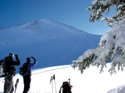
Winter Recreation in the La Sal Mountains |
 When the weather in Moab gets cold, freezing the Colorado River and putting snow and ice on everybody’s favorite bike trail or climbing route, there is another alternative available. Find yourself in an inversion? It is time to go and discover the recreation opportunities in the La Sal Mountains. When the weather in Moab gets cold, freezing the Colorado River and putting snow and ice on everybody’s favorite bike trail or climbing route, there is another alternative available. Find yourself in an inversion? It is time to go and discover the recreation opportunities in the La Sal Mountains.
The La Sals are second only to the Uintas as the highest peaks in the state of Utah. These mountains soar to almost 13,000 feet above sea level and over 8,000 feet above the valley floor. A laccolith process formed the La Sals. With this process, a mass of igneous rock intruded between layers of sedimentary rock, resulting in uplift. You could call them frustrated volcanoes too. Aside from the volcanoes of the Pacific-Northwest, there are no peaks with greater rise in the continental U.S.
Winter recreation in the La Sals includes cross country skiing, skate skiing, snowshoeing, sledding, back-country skiing and snowmobiling. The winter access to the mountains is provided from two routes kept open by the Grand and San Juan County Road Departments.
1. The La Sal Mountain Loop Road is plowed regularly. The Geyser Pass road is kept open to the restrooms and parking area at 9,600’. The Geyser Pass Road and Gold Basin Road beyond the winter trailhead is a popular area for cross country skiing, snowshoeing and snowmobiling. Groomed trails are provided by the Lower Utah Nordic Alliance (LUNA). Volunteers groom trails approximately twice a week, which provide 12 kilometers of a groomed trail-system, open to every winter user group. These roads also provide access to backcountry skiing and snowboarding in the Mt. Tomasaki and Gold Basin areas. There is a sledding hill just below the parking lot. If you are using the sledding hill, please park in the parking lot so other vehicles can get to the parking lot. The road in the winter is narrow enough!
Snowmobiles are not allowed to leave the road in Gold Basin. Please respect this closure of the most popular skiing area in the La Sals - the rest of the entire range is open to you!
2. From near Old La Sal at the south end of the range, the road is plowed regularly two miles short of Dark Canyon Lake, just below Mount Peale. The San Juan Road Department makes a parking lot at about 9,600’.
Winter Huts are available for rent from…
Tag-A-Long Tours: 435-259-8946. These simple cabins are great for folks who want to spend several days in the mountains, but don’t want to lose a couple of hours driving back and forth from town every day. The hut operators can snow cat your supplies and camping gear in for you saving you the heavy carry.
Avalanche Hazard
in the La Sal Mountains
The La Sals are rubbly piles of fractured stone.
The angle of repose for this broken stone is 38 degrees, and since snow is also a granular substance, 38 degrees is the bulls-eye slope angle for snow avalanches. Keep in mind though, that avalanches run on terrain from 30 - 45 degrees. Most people caught in avalanches are in terrain that is 30 - 35 degrees of steepness. The La Sal Mountains usually possess one of the weakest snow packs imaginable.
Why do we care? Because 30% of people completely buried by avalanches are killed by trauma and many of those remaining die from suffocation. These are not good odds. It’s not good policy to plan on outrunning an avalanche, even on a fast snowmobile, because avalanches have been clocked at well over 200 mph. Grim statistics showing that snowmobilers are the most likely people to be killed in avalanches also support this.
So what do we do? Fortunately, staying safe doesn’t have to mean staying at home! The good news is that most people trigger the slide that catches them, so if we learn a little about snow and adjust our behavior to suit the conditions, we can continue to enjoy our winter playground!
The Utah Avalanche Center - Moab exists to help you make the right decisions. The Utah Avalanche Center - Moab Forecasters examine the snow and produce an advisory informing you of where you are most likely to run into problems and just how sensitive the snow is. They also produce a mountain weather forecast, work with the Moab Winter Search and Rescue Team and provide avalanche education to the community in numerous ways. The Utah Avalanche Center - Moab educates the community through the advisories, classes held periodically, radio announcements on the weekends on KZMU, the website and at the Geyser Pass Trailhead information board. The center director is Max Forgensi. For more information you can contact Max Forgensi at 435-636-3355
The website is a great tool for:
• Finding a weather forecast for the Moab area,
including radar images
• A current photo gallery of the La Sal Mountains
• Advisories for the La Sals and the Abajo Mountains
• A current course schedule for southeast Utah
Watch for periodic special events like ski swaps and avalanche awareness classes. If you need to talk to one of the avalanche forecasters, please call 259-7155 Monday-Friday during normal business hours and be sure to mention you read about it in Moab Happenings.
For Current Advisories
259-SNOW (7669)
888-999-4019
www.utahavalanchecenter.org
or on facebook.com at
the UtahAvalancheCenterMoab site |
Avalanche Classes
On Friday evening, January 18th at 6:30 pm at the Grand County Public Library, there will be a Basic Avalanche Awareness talk for the public. The following morning, Saturday, January 19th, @ 10:00 am, there will be a follow up on the snow beacon training for interested individuals.
For those who are interested in a more detailed training, the Utah Avalanche Center - Moab will be conducting a 3 day American Institute for Avalanche Research and Education (AIARE) Level I class from February 1st - 3rd...weather dependent. The course will cost $150, proceeds of which will go to the Friends of the La Sal Avalanche Center, a non-profit organization partnered with the UAC-Moab.
Details on this class will be found at the website and facebook page.
|
|
|