If you want a strenuous workout, the Stairmaster is the trail for you. Climbing 1,000 feet in approximately one mile, sometimes at an unrelenting grade of 25%, clearly indicates how this powerhouse course received its name. Doing this on a daily basis should whip anyone in to shape! 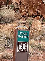
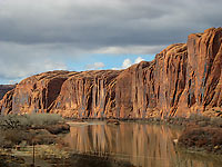
Paralleling the Moab Rim jeep trail, this hikers-only, alternative route wraps beneath sheer cliffs of Navajo and Kayenta Sandstone. As it climbs higher I am entranced with the constantly changing perspective of the Colorado River, especially when it is showing its best face.
The heavy load of silt from last year’s spring run-off has long since settled out, and in its place a lovely blue-green cloak gleams with reddish reflections from the cliff walls that tower above.
The formation of our canyons started about ten million years ago when this area was uplifted several thousand feet by tectonic forces. As the land continued to rise, the pressure and volume of water increased. This forced the river to cut deeper into the thick solid layers of sandstone chiseling out the sheer walls that are so familiar to us today.
To get to the Stairmaster Trail, turn at McDonald’s on to Kane Creek Blvd. At the stop sign go straight for 3.5 miles to the trailhead. At the trail register the sign for the Stairmaster will be to your right. Be forewarned: on the rocky, ledgy sections, it takes a lot of detective work to stay on course.
 Despite a fierce, cold wind nipping at my heels, I still entertain visions of spring as I start my lung buster hike. After all, it is early March so wildflowers and sunny, warm days can’t be that far away. Looking around, ah yes, the Newberry twinpod is about to burst forth with its petite sprigs of yellow. This time of year I always look forward to the shy beauty of our first bloomer of the season. Despite a fierce, cold wind nipping at my heels, I still entertain visions of spring as I start my lung buster hike. After all, it is early March so wildflowers and sunny, warm days can’t be that far away. Looking around, ah yes, the Newberry twinpod is about to burst forth with its petite sprigs of yellow. This time of year I always look forward to the shy beauty of our first bloomer of the season.
Casting my vision across the river I scroll up almost to the top of the cliff wall to locate Little Arch. From this unapproachable point of view, it is hard to imagine that from the opposite direction the Poison Spider trail passes directly above this unique landmark. Before long, however, as I gain elevation, Little Arch is no longer visible.
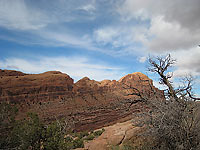
Now glancing over at the cliff-face, rimrocked skyline, there it is – the distinctive v-shaped indentation that I refer to as “The Notch.” Far below that, I can easily pick out and hear hikers on the trail to the Portal Overlook. Farther downriver I turn my attention to the well-known climbing wall referred to as “Wall Street” – a popular place for climbers to hone their skills. Finally stretching my vision to the far away horizon, I can actually see the rim line that borders Dead Horse Point State Park and Canyonlands National Park.
 Sandstone, lack of soil and aridity force the vegetation along this trail to take a low profile. Stunted, gnarled junipers are few and far between as each one struggles for its own existence in meager pockets of dirt. In more fertile areas the blackbrush, Mormon tea, snakeweed, singleleaf ash, cliffrose and oaks do grow and even manage to thrive - a perfect haven for the sparrow-sized juncos that flitter in and out of this thicker vegetation. With a flash of their outer white tail feathers, a quick look is usually all these energetic birds will give me. Sandstone, lack of soil and aridity force the vegetation along this trail to take a low profile. Stunted, gnarled junipers are few and far between as each one struggles for its own existence in meager pockets of dirt. In more fertile areas the blackbrush, Mormon tea, snakeweed, singleleaf ash, cliffrose and oaks do grow and even manage to thrive - a perfect haven for the sparrow-sized juncos that flitter in and out of this thicker vegetation. With a flash of their outer white tail feathers, a quick look is usually all these energetic birds will give me.
Over the years, truck-sized boulders have broken off the cliff face and like a shot out of a cannon they rumbled and tumbled to the ground. Each one is covered with its own family of lichens. And what are lichens, you ask? Lichens are a composite organism made up of a fungus and bacterium that forms a rough, crust like growth on rocks or tree trunks. They come in shades of green, gray, yellow, brown or black. My favorite ones on this walk swirl around on the rock face in wild configurations of bright yellow.
Finally – Hallelujah - the climax, my pilgrimage to the top of the Stairmaster, where it joins the Moab Rim jeep trail, is done! As I follow a short spur to a viewpoint, I am rejoicing that the uphill struggle is behind me. Now I am ready for a break, and plop goes my pack to the ground with me dropping down beside it. Ah that feels good as I settle in to reap the rewards of this tremendous king-sized view: the Bookcliffs, short sections of the river, “The Windows” in Arches National Park, the mystically white vision of the La Sal Mountains, humungous domes that flank the Behind The Rocks Wilderness Study Area, the Sand Flats Recreation Area and a deep gash that belongs to Mill Creek Canyon. All of Moab Valley can also be seen: the cultivated fields, the Matheson Preserve, the bridge over the river, hotels, restaurants, churches, schools, the hospital, condos, homes, etc. 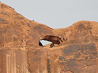
Relaxing over a leisurely lunch, I am ecstatic to be at this marvelous on-the-edge spot on the Moab Rim. It was definitely worth every minute of the hard workout climbing up – and what’s more, the difficult part is over. From now on, it’s downhill all the way back!
The Moab Rim trail continues south as it travels through a slickrocked area between two large domes of Navajo Sandstone. Then it goes along a wash bottom and up a large sand hill where there are several spurs to viewpoints of Spanish Valley. After another portion of foot dragging sand, it hooks up with the Hidden Valley trail. If you arrange a shuttle, the entire one-way trip is six miles long.
|