Oh yeah! At last the sun does shine. After a long string of overcast days, I’m not wasting a second of this clear-sky opportunity. Finishing a quick breakfast, I’m out the door and down the road to the Sand Flats Recreation Area. Amazingly, except for the heavy frost, everywhere I look the ground is bone dry. For too many end-of-January hikes, I’ve plowed through a ton of snow, so I’m not taking any chances of waiting for a warmer day. The trail is dry today, where as tomorrow it could be inundated with snow. 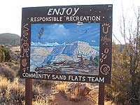
On this foot-stomping, invigorating morning, I am trying hard to wrap my head around the fact that approximately 150 million years ago the Colorado Plateau was situated near the equator - a Sahara-like desert filled with shifting dunes of sand! Then millions of years later, those restless grains of sand petrified into Navajo Sandstone, leaving behind the rounded slickrock that we are familiar with today.
Sand Flats receives approximately 150,000 visitors a year. Famous for the Slickrock Bike trail, along with 40 miles of jeep trails, this unique tract of land is a mere ten minute drive from downtown Moab. But don’t let that biker-jeeper perception mislead you. The hiking opportunities, especially during the quietude of winter, with its wide-screen, full circle panoramic views shouldn’t be overlooked.
Before 1995, this precious resource had become an out-of-control place to party. With so many people having way too much fun, it ended up being trashed. As the abuses increased, the community of Moab realized something needed to be done to stop this destruction. Consequently an unusual partnership was formed between Grand County and the Bureau Of Land Management so they could maintain, manage and rehabilitate this area, while still providing access to sustainable and enjoyable recreational opportunities. 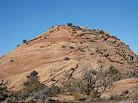
In order to meet these goals, it became necessary to charge entrance and camping fees: Day pass - $5, weekly pass - $10, annual pass - $25, and camping - $15. One hundred twenty campsites are open year round on a first come, first serve basis, and many campsites can accommodate RVs, but there are no hook-ups. Water is not available, and in the heat of the summer you need to bring a truckload.
To get there, turn east off of Main Street at the Moab Information Center on to Center Street. At the stop sign on 400 East, go right, drive five blocks and turn left at Dave’s Corner Market on to Mill Creek Drive. At the three-way stop, go straight and drive 1.7 miles on the Sand Flats Road to the entrance booth.
Approximately 5.2 more miles beyond the entrance booth, the lower access for the Porcupine 4X4 trail is marked with a “you are here” map. At this spot, I pause a few minutes before starting my hike so I can appreciate the panoramic picture postcard scene - the La Sal Mountains with their above average payload of snow and the jagged outline of Behind The Rocks. Completing this full circle scan I pick out the deep canyon on the north end of Moab Valley, the southern boundary of Arches National Park, and the long sweep of the Porcupine Rim and South Mesa. 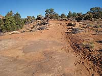
This rutted jeep trail, which is approximately three miles long, is well marked and easy to follow – a route that travels over rocks, sand, slickrock and numerous ledges. Fresh tire tracks indicate I’m not the first person here this winter, but today it is blessedly empty and quiet. Then suddenly, the silence is pierced by a legion of raucous pinyon jays. As they fly directly below a waning half moon, this unusual and haunting image stays with me all day. These avian gypsies wander over long distances in search of their specialized diet of pine nuts, so one never knows when they might show up.
Moving along I notice the crytobiotic (known as cryptos) crust has recovered and thrives. Looking at its bumpy, blackish-tar appearance, a first time visitor would never guess it’s alive. Composed of algae, bacteria, lichens, moss, and fungi it serves an important niche in the ecology of the desert. By binding the soil and sand it prevents them from blowing away. It also slows down water runoff as it retains and absorbs moisture so I try hard not to step on it.
The road immediately starts winding around a big outcrop of rock where an intriguing behind-the-scene presentation comes in to view. Through a v-shaped notch the peaks of Tukuhnikivatz, Tuk No, and Laurel gradually pop in to sight. When I reach the right position, sunlight highlights them to portray the glazed over look of scoops of vanilla ice cream.
In about a half-mile I go right at the first marked junction. Not much farther, I reach the next junction with a map, and again I take a right. Before long a big drop in elevation takes me to the border of the Negro Bill Wilderness Study Area, which is named after William Grandstaff, an African-American rancher and prospector, who came to the Moab Valley in the spring of 1877. 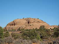
I always say the desert is full of surprises, and before long the oasis of Negro Bill Canyon with its perennial stream is one of them. Starting at the Porcupine Rim this riparian gem collects a huge watershed as it travels to the Colorado River, where the name of the two mile trail to Morning Glory Arch has been changed from Negro Bill to Grandstaff. Usually I’m in the bottom looking up. Today I’m on top peering down on its scalloped, rocky bottom that collects pools of water and the cottonwood trees growing on its outer banks. Being able to follow the south rim of this canyon for almost a mile is what makes this hike so unique and special.
The sun radiating off the rocks has taken the chill off the day and I can’t resist taking a break. This warmth brings on thoughts of spring, and with this upbeat rise in temperature, I’m tempted to stay here all afternoon. But the days are still short, I have a lot more ground to cover, and so reluctantly, I move along.
As the trail goes back up, the canyon gradually disappears from sight. Almost to the end, it wanders all over creation to by-pass the steep, ledgy slope below the Sand Flats Road. At last, it joins up with the Porcupine Rim trail. Shortly after that, I’m at the trailhead next to a spring that fills an overflowing water trough.
Feeling like I’ve had enough of a workout, I’m grateful my husband ran a shuttle. That saves me a walk back on the road or a return hike down the trail.
|