Envision this: You’re watching a movie with a Sahara Desert-like setting where you are awed by the stark silence as the camera calmly sweeps over an endless land of shifting sand. Suddenly tranquility is lost. With a deafening roar, the wind kicks up a dust bowl of flying debris as it ferociously shapes and reshapes the landscape. Watching the visibility dropping to zilch, you can almost feel the biting sand sting your skin, clog your nose and burn your eyes. 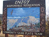
“So where in the world,” you ask, “could this have been filmed?” To answer that question you need to travel back 150 million years to southeast Utah, which at that time was located near the equator! Then step forward in geologic time to the epoch when these wandering sand dunes stopped moving and petrified into Navajo Sandstone, leaving behind the rounded slickrock we see today in the Sand Flats Recreation Area.
From near and far mountain bikers and four wheelers flock to the Sand Flats Recreation Area. Famous for the Slickrock and Porcupine Rim bike routes and almost 40 miles of jeep trails, this backyard gem is a mere ten minute drive from downtown Moab. But don’t let that biker-jeeper perception discourage you. The hiking opportunities, especially in the quietude of winter, shouldn’t be overlooked.
Bordered by two wilderness study areas – Negro Bill to the north, Mill Creek to the south – this popular playground receives at least 100,000 visitors a year. Responding to the recreational overload, in 1995 the Moab community, Americorps, Grand County and the Bureau of Land Management (BLM) collaborated to protect this precious resource. Consequently, the county and the BLM formed an unusual partnership to maintain, manage and rehabilitate its 7,320 acres.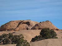
To get there, turn east off of Main Street at the Moab Information Center on to Center Street. Proceed to the stop sign on 400 East, and turn right. Then drive five blocks and turn left at Dave’s Corner Market on to Mill Creek Drive. At the three-way stop, go straight and drive 1.7 miles on the Sand Flats Road to the entrance booth.
The entirety of the Fins And Things jeep trail is 9.4 miles long, but since it advantageously parallels the Sand Flats Road you can enter and exit at various intervals for a much shorter hike. After passing the entrance booth, I continue 1.4 more miles until I reach the sign on the left indicating the north loop of Fins And Things, where my hike begins.
As I step out of my car a breeze with a very sharp bite greets me with a frosty kiss. Hastily I pull on more layers of clothes. But after looking up at the raging wind driving plumes of powdered snow over the higher peaks of the La Sals to the heavens above - I realize no way should I be whining about a puny movement of air down here!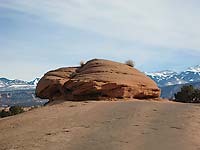
Immediately after passing through the opening in the barbed-wire fence, I hear the bell-like call of a scrub jay coming from the other side of a nearby juniper. Hoping for a close up look at this energetic bird, I try the “stay put and wait” technique. Patience pays off. Before long he’s on the ground just a few feet away scrounging up his breakfast giving me a chance to soak in his azure-blue head, wings and tail that brighten up a somber, wintry day. When he finally takes off, so do I. Dallying around on this frigid morning to watch this lively bird has left me with cold feet.
A short distance later when the trail splits, I hang a left and walk by a big rock formation that imaginatively impresses me as a gentle dragon taking a nap. Shortly after that, a stony, prehistoric monster appears to be following another big monster. Then my eye is drawn up to the top of these sculptured pieces of rock, and what do I see? - a real live, very big bird with glints of gold. Oh Wow – I’m staring at a golden eagle - one of the largest birds of prey in North America!
Thank goodness the worst of winter hasn’t hit yet and the slickrock is free and clear of snow. Even on the steepest grade the grip is secure as I walk on this up-and-down roller coaster course of a trail. Every once in awhile I drop into a sheltered hollow. And where there is fertile dirt, the small dish gardens grow - a profusion of pinyons, junipers, snakeweed, oaks, Indian rice grass, yucca, prickly pear and Mormon tea.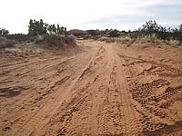
A mile farther, there’s another split in the trail, and again I go left. Not long after that at the tippy top of a rounded mound of slickrock, I reach the end of the loop where I stop for a hunkered-down break. How can I pass up this unbeatable view that stretches from 4500 feet to over 12,000 feet - a leap in elevation from high desert mesas to the alpine peaks of the La Sals – an expansive wilderness that can easily gobble you up and cast a spell that never lets you go - a place where the possibilities of exploration are endless.
I have this magnificent scene all to myself, and the rare silence that comes with the solitude of the season. Savoring this special interlude of winter, however, I haven’t been paying close attention to a change in the weather. To my dismay I suddenly realize the clouds have bunched up to change the sky to a milky-white curtain. Now with all chance of some sunshine and warmth suddenly gone, and no place to hide from a nagging breeze, I’ve had enough. It is definitely time to leave!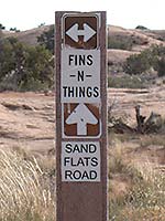
Heading back I continue past the alternate route, and at the next fork I swing left to hike the upper trail rather than follow my original route back. In other words, I’ve taken the low road in, and now I’ll follow the high road out.
At a high point next to a turtle-shaped rock, I can’t resist another quick break to absorb the full-screen picture of castle-like formations on the northern horizon. As I look the opposite direction the panorama rolls on with the jagged outline of Behind The Rocks on the southwestern skyline above Spanish Valley.
Continuing on, when I reach the Fins And Things sign, I follow the arrow pointing to the Sand Flats Road to the intersection from where I started. Now retracing my footprints before long I reach the welcome shelter of my vehicle ending an invigorating 2.6-mile loop hike!