HIKING HAPPENINGS January 2014
The jagged profile of the Moab Rim is a geologic wonder that never ceases to amaze me. After all, how could I possibly get bored with the dynamic stance of this 1800 foot Navajo Sandstone precipice that dominates Moab’s southwestern skyline – a formidable fortress that towers above the entire length of the Pipe Dream Trail. Consequently, whenever I take a walk on this relatively new pathway, the Rim’s powerful presence never deserts me. 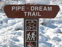 Due to its close proximity to town this so-easy-to-get-to trail is becoming a favorite with both tourists and locals. For some nearby residents, it’s the convenience of literally stepping out the door. For everyone else in the valley it is merely minutes away to where a lovely hike awaits, a definite plus over wasting time and gas. Due to its close proximity to town this so-easy-to-get-to trail is becoming a favorite with both tourists and locals. For some nearby residents, it’s the convenience of literally stepping out the door. For everyone else in the valley it is merely minutes away to where a lovely hike awaits, a definite plus over wasting time and gas.On June 17, 2011 our community was invited to celebrate the completion of the Pipe Dream Trail. After a brief ribbon cutting ceremony at the Hidden Valley parking area a small group of bikers christened it with a single file “critical mass” ride north to its last exit at Aspen Street in Moab. Hikers were also welcome to walk the same 4.8 mile route - or they could opt for a much easier one mile loop near the trailhead. Once upon a time the naysayers said it could not be built; they insisted that too many obstacles stood in the way. In their opinion it was nothing but a pipe dream. Other determined souls, however, proved them wrong and a seemingly impossible dream finally came true - a close-to-town trail offering stunning views of the La Sal Mountains and a bird’s eye view of Moab and Spanish Valley as it wanders under the mighty profile of the Moab Rim. 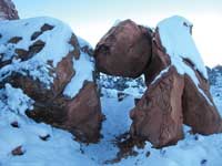 The creation of this unusual route involved some extensive trail work through a vast area of improbable terrain. Since it had to be carved out of a side hill, it required approximately 2,000 volunteer hours, 4,000 paid trail worker hours and the movement of a humungous amount of rock. Under the guidance of David Olsen and Scott Escott, boulder bridges were built across dips and drainages and rock causeways connected corners and switchbacks as they climbed the bench cuts. Much of the trail is surfaced with slab stone in order to minimize erosion. Funding for its construction came from the city of Moab and was matched by the Recreational Trail Program, which is administered by the State of Utah Trails and Pathways Program. Additional funding came from Trail Mix, a foundation grant and the Workforce Services WIA Youth program. The creation of this unusual route involved some extensive trail work through a vast area of improbable terrain. Since it had to be carved out of a side hill, it required approximately 2,000 volunteer hours, 4,000 paid trail worker hours and the movement of a humungous amount of rock. Under the guidance of David Olsen and Scott Escott, boulder bridges were built across dips and drainages and rock causeways connected corners and switchbacks as they climbed the bench cuts. Much of the trail is surfaced with slab stone in order to minimize erosion. Funding for its construction came from the city of Moab and was matched by the Recreational Trail Program, which is administered by the State of Utah Trails and Pathways Program. Additional funding came from Trail Mix, a foundation grant and the Workforce Services WIA Youth program.Running along a steep slope on the southwest corner of Moab Valley, this rugged trail has its share of ups and downs, but in reality from start to finish there is only a 500 foot change in elevation, from 4200 feet in town to 4700 feet at Hidden Valley. With tight turns and steep side slopes, it is rated intermediate to advanced for bike riders but is easily negotiable for hikers and runners. 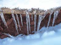 The trail parallels Highway 191 and the three major trailheads can be accessed from this major artery. The following directions are for a north to south orientation. Your three choices are: in town go left on Aspen Street off of Kane Creek Blvd. and then right on to Doc Allen Drive -- at the south end of town at the light take a right on to Jackson Street (400 East) -- or drive 3.5 miles south of town and take a right on to Angel Rock Road at the stucco dental office building, which is followed by a right on to Rimrock Road. At the parking area there are signs for both the Hidden Valley and Pipe Dream Trails. The trail parallels Highway 191 and the three major trailheads can be accessed from this major artery. The following directions are for a north to south orientation. Your three choices are: in town go left on Aspen Street off of Kane Creek Blvd. and then right on to Doc Allen Drive -- at the south end of town at the light take a right on to Jackson Street (400 East) -- or drive 3.5 miles south of town and take a right on to Angel Rock Road at the stucco dental office building, which is followed by a right on to Rimrock Road. At the parking area there are signs for both the Hidden Valley and Pipe Dream Trails.In early December I’m looking for a trail that is doable in the snow. After much inner debate I decide to give the Pipe Dream Trail a try. I am pleasantly surprised to discover that someone with a dog has already power-walked a path- way through and packed the snow down so I am able to follow the tracks and stay on course. Now rather than floundering around in knee-deep snow I can instead concentrate my energies on the beautiful wintry world that surrounds me – the crystal-clear icicles dangling from the rocks - the Christmas tree scene of junipers decorated with a heavy load of powdery fluff – the distinctive pattern of cottontail tracks. This captivating scene continues with a sugar-coated boulder field of gigantic rocks guarded by towering sandstone sentinels – the creamy whimsical beauty of the La Sals – and a dazzling display of crystallized snow that glitters like thousands of sparkling diamonds. Part way through my hike I quickly pause to gaze upon a noisy flock of Canada geese winging their way south. 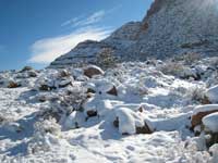 It’s too cold to stop for more than a few seconds, but hey at least the sun is shining and I keep steadily tramping along. There are tricky places where footing is not that secure, and sometimes it’s a slip-sliding-away experience. At one spot the trail knots itself into a u-turn; a short distance after that a rock tunnel is so intriguing as I walk through an opening that was created when one rock fell on top of another. It’s too cold to stop for more than a few seconds, but hey at least the sun is shining and I keep steadily tramping along. There are tricky places where footing is not that secure, and sometimes it’s a slip-sliding-away experience. At one spot the trail knots itself into a u-turn; a short distance after that a rock tunnel is so intriguing as I walk through an opening that was created when one rock fell on top of another.The sun disappears early on this side of the valley; by 1:00 it is already dropping below the horizon! Suddenly the shadows are deep and it is bitterly cold. In winter there’s plenty of unwanted shade. Ironically, during the scorching heat of summer, shade is hard to come by. But despite the biting cold I continue past the first map marker sign that tells me I’ve covered more than a mile. By the time I reach the second sign the footprints stop and so do I. I’ve had enough. The cold is plunging through me like a knife, and it’s time to head back before I turn into a pillar of ice! The good news is that being so close to home I can conveniently return whenever I desire for a quick outing or to explore a more extensive stretch of terrain that promises to take me all the way into town. |