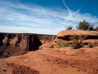
Along the edge of sheer cliffs a narrow mesa runs its course until it terminates at a dramatic overlook known as Dead Horse Point. At an elevation of 6,000 feet, this spectacular on-the-edge viewpoint presents an expansive, mind-boggling scene – a tremendous 2,000 foot drop, which extends to the shores of the Colorado River and far, far beyond for miles and miles across a fractured landscape - a massive tangled web of canyons, mesas, buttes, fins and spires, which finally climaxes at the La Sal Mountains on the eastern horizon and the Abajos to the south.
The name Dead Horse supposedly derives from an era when wild mustangs freely roamed throughout the west. Their ancestors arrived in the New World with the Spanish conquistadors in the 1500s. Three hundred years later, cowboys had devised clever ways to capture them, and Dead Horse Point provided the perfect setting for a custom-made trap. After herding the ponies past the narrow strip of land called the “neck,” a quick placement of juniper and pinyon pine branches fenced them in. With sheer cliffs blocking escape routes on all sides, it became a convenient corral where the cowboys could sort out the healthy marketable ponies from the culls referred to as “broomtails.” As the story goes, a band of broomtails was accidentally left behind, and with no exit they died of thirst leaving behind the name of Dead Horse Point.
More than 50 million years ago, herds of much smaller, different looking wild horses, hunted by prehistoric predators, inhabited the North American continent. These ancient equines had developed specialized teeth to process the coarse prairie grass rather than browsing on leaves. Using this successful strategy they thrived, and yet mysteriously disappeared during the last Ice Age about 10,000 years ago. It was on other continents that horses evolved into their modern form and were eventually domesticated by man.
When San Juan County officials recognized the scenic and geologic value of this area, they purchased 628 acres from the Bureau of Land Management and donated it to the Utah Parks and Recreation Commission. Since its dedication in 1959 as a state park, Dead Horse has grown to over 5,000 acres and hosts almost 200,000 visitors a year.
To get there, drive nine miles north from Moab on Highway 191 and turn left on Highway 313. Then continue fourteen miles to the turn off for Dead Horse Point State Park. From there it is seven miles to the visitor center.
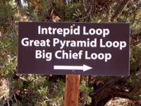
The paved road ends at the Dead Horse Point Overlook. You, however, observe so much more by taking a hike on the Intrepid Trail System. Don’t let the word “Intrepid” scare you away; it is hardly as ominous as it sounds. Built in 2009, the trails are not named for any extreme exposure - but for the Intrepid Potash Company, whose generous donation made this popular mountain biking trail possible. This moderately easy series of trails contains an overlook on each of its three loops: The Intrepid – 1.1 miles, Great Pyramid – 4.2 miles, and Big Chief – 9 miles. Each intersection displays a map with an arrow marking your exact location, as well as obvious signs, which makes this self prompting pathway almost as easy as following the yellow brick road! A shorter path starting at the Visitors Center is also available as a hikers-only trail.
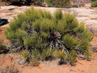
The trail begins at the north end of the parking area. At the trailhead I am trying to decide, what loop should I take? Gradually I come to the conclusion that the Intrepid Loop is too short, the Big Chief is too long, but the Great Pyramid is just right. Finally concluding that debate, I’m heading out across a wide-open mesa on an easy-going track, a compatible route for both hikers and bikers. Nothing about it is hard-core, which makes it perfect for a leisurely two-wheeled excursion for families on an outing with the kids. No one is in a hurry, everyone wears a big smile, and the leisurely pace allows me plenty of time to step aside.
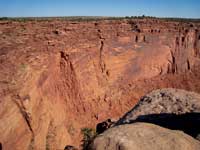
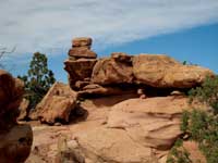
Approximately two miles later, I reach the Great Pyramid Overlook and witness a mind-blowing portrayal of 300 million years of Earth’s geologic history! All along this rim, rock layers were deposited over eons by ancient oceans, wind blown sand dunes and flood plains. Born during a regional uplift, the Colorado River has been carving through the sediments ever since, exposing the colorful consecutive bands of Kayenta, Wingate, Chinle, Moenkope and Cutler Sandstone.
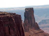
This overlook is named for Pyramid Butte, a landmark with an amazing similarity to an Egyptian pyramid. Another formation that dominates the scene is Tower Butte, which has the brute appearance of a gigantic tower. The Shaefer Trail, a jeep road used for traveling from the mesa top to the White Rim, is also evident, along with the uranium mining roads that precariously skirt the western edge of Shaefer Canyon.
Engrossing as this overwhelming scene is, a glance at my watch convinces me I really should move along; but I don’t stand up in a hurry. Sitting precariously close to the abyss, I ever so cautiously step back to safer ground!
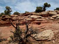
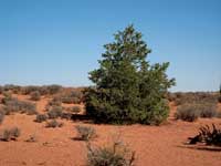
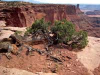
The trail now makes a big bend along the side of a small cliff as it gently climbs back to the wide-open mesa. Soon I’ve reached the intersection where my walk back to the parking area begins. On this hike, along with the dramatic views, I have relished the more subtle riches this high desert country has to offer - the whispering breezes that rattle the blackbrush, the Mormon tea, pinyon pines, junipers and saltbush – the scattered pin cushion gardens of prickly pear cactus - the radiant warmth of the sun - the raven’s booming call - the charming chortle of a titmouse. . .