HIKING HAPPENINGS March 2012
Fins & Things – From “E” To “F”
article and photos by Marcy Hafner
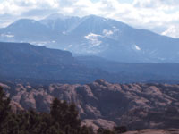
The Sand Flats Recreation Area is renowned for the Slickrock and Porcupine Rim bike trails and the almost 40 miles of off-road jeep routes. But don’t let that biker-jeeper perception mislead you. With its spectacular big picture scenery, this backyard gem is compatible for hikers, too. Since it is a very short drive from downtown Moab, I come here often, especially in the off-season, to savor the stunning full circle horizontal panorama of Arches National Park, Porcupine Rim, the La Sal Mountains and Behind The Rocks – a wide screen composition bordered by lofty alpine peaks that contrast sharply against the red rock desert thousands of feet below.
 Touching its borders with two wilderness study areas – Negro Bill to the north, Mill Creek to the south - this unique playground receives almost 100,000 visitors every year. In response to the recreational overload, the Moab community, Americorps, Grand County and the Bureau of Land Management (BLM) collaborated in 1995 to preserve this precious resource. This coalition precipitated a unique partnership between the county and the BLM so they could manage, protect and rehabilitate while also providing access to the public for an environmentally friendly experience. Touching its borders with two wilderness study areas – Negro Bill to the north, Mill Creek to the south - this unique playground receives almost 100,000 visitors every year. In response to the recreational overload, the Moab community, Americorps, Grand County and the Bureau of Land Management (BLM) collaborated in 1995 to preserve this precious resource. This coalition precipitated a unique partnership between the county and the BLM so they could manage, protect and rehabilitate while also providing access to the public for an environmentally friendly experience.
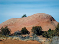
During the Jurassic period, way back 150 million years ago, it’s mind boggling to realize that the Colorado Plateau was situated near the equator in a hot, dry land of shifting sand! Over the eons these huge sand dunes petrified into Navajo Sandstone, leaving behind the rounded domes and fins that are so characteristic of the landscape we see today throughout Sand Flats.
 To get to this outstanding recreational area, turn east off Main Street at the Moab Information Center on to Center Street. At 400 East go right. Then turn left at Dave’s Corner Market on to Mill Creek Drive and continue up the steep winding road to the entrance booth. To get to this outstanding recreational area, turn east off Main Street at the Moab Information Center on to Center Street. At 400 East go right. Then turn left at Dave’s Corner Market on to Mill Creek Drive and continue up the steep winding road to the entrance booth.
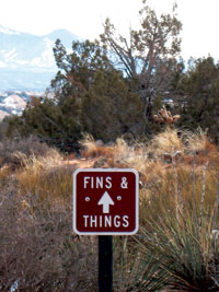 The entirety of the Fins & Things jeep trail is 9.4 miles, but since it parallels the Sand Flats Road you can easily enter and exit at various intervals for a much shorter hike. Two miles beyond the entrance a less known portion starts in Campground E between campsites five and six, and ends at Campground F. The entirety of the Fins & Things jeep trail is 9.4 miles, but since it parallels the Sand Flats Road you can easily enter and exit at various intervals for a much shorter hike. Two miles beyond the entrance a less known portion starts in Campground E between campsites five and six, and ends at Campground F.
The up and down roller coaster sensation of this trail steadily alternates from slickrock mounds to sandy hills with a few flat spots in between. With the white dinosaurs painted on the slickrock and metal signs regularly placed along the sandy sections, this 1.8 mile route is easy to follow. The only requirements essential for completing the course are a reserve of stamina to march up the steeper hills, and a pair of hiking shoes that grip well, particularly on the downhill.
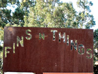
The entrance to the trail is posted with a brown metal “Fins N Things” sign while the bulletin board provides valuable and interesting information. In the mailbox I find booklets that include maps, which are very useful.
Up the first rocky hill, I’m immediately peering down on the campground. After that, it doesn’t take long before I’m noticing leftover patches of snow on the north-facing slopes. The road, however, mainly traverses along a southern exposure where a dry path makes me very happy.
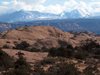 Quickly I gain enough elevation to have that full circle view. On this blustery day the majority of the La Sals have disappeared in thick, swirling clouds. The only peaks not engulfed are Haystack and South Mountain, which stick out in sharp relief against the whirling haze. The lower landscape in the Mill Creek Wilderness Study Area projects a jumbled land of giant sized fins and mounds - a stacked deck of uprising slabs of rock suggesting an overwhelming maze that won’t release you from the towering sandstone structures. Quickly I gain enough elevation to have that full circle view. On this blustery day the majority of the La Sals have disappeared in thick, swirling clouds. The only peaks not engulfed are Haystack and South Mountain, which stick out in sharp relief against the whirling haze. The lower landscape in the Mill Creek Wilderness Study Area projects a jumbled land of giant sized fins and mounds - a stacked deck of uprising slabs of rock suggesting an overwhelming maze that won’t release you from the towering sandstone structures.
 After a while the trail splits and I travel left for a slightly longer loop. Power walking up a long humpback of slickrock, a cutting breeze greets me at the top. For the descent, I struggle to keep my feet from sliding out as gravity pushes me along. This off-road obstacle course must be a huge challenge for four-wheel drivers - the swath of black left on these incredibly steep slopes tell the tale of a lot of tire spinning! After a while the trail splits and I travel left for a slightly longer loop. Power walking up a long humpback of slickrock, a cutting breeze greets me at the top. For the descent, I struggle to keep my feet from sliding out as gravity pushes me along. This off-road obstacle course must be a huge challenge for four-wheel drivers - the swath of black left on these incredibly steep slopes tell the tale of a lot of tire spinning!
Gradually the trail starts swinging down a sandy slope. Many steps later, a faint image of Campground F appears– my tantalizing goal, still so far below! But a gradual, gentle-on-your-knees grade allows for an easy-going walk down. Now I am searching for a wind-free spot, which I know is wishful thinking! A rock wall buffered by a juniper, however, provides adequate protection, and I snuggle in for a much needed, only slightly breezy break.
Not a soul is in this campground and I feel blessed to have this lovely spot all to myself. The peace and quiet washes over me as I listen to the soothing chortle of a juniper titmouse. Twisting around to seek him out, he flies down to check me out - just five feet away! He’s obviously used to people, and I relish this special opportunity to watch this charming gray crested bird so closely. As the name implies, these energetic, acrobatic sprites are usually found in pinyon-juniper woodlands. Like their chickadee cousins, they are hardy and tenacious. Through the wind, the cold, the snow and our desert heat, these endearing birds persist and thrive.
Finally my curious titmouse departs and so must I. With a sigh, I shoulder my pack and head back into the wind for my return trip to Campground E.
|
Biological Soil Crust (aka)
Cryptos (krip’ tose):
The surface of
Moab’s desert is held
together by a thin skin of living organisms known as cryptobiotic
soil or cryptos. It has a lumpy black appearance, is very
fragile, and takes decades to heal when it has been damaged.
This soil is a critical part of the survival of the desert.
The cryptobiotic organisms help to stabilize the soil, hold
moisture, and provide protection for germination of the seeds
of other plants. Without it the dry areas of the west would
be much different. Although some disturbance is normal and
helps the soil to capture moisture, excessive disturbance
by hooves, bicycle tires and hiking boots has been shown
to destroy the cryptobiotic organisms and their contribution
to the soil. When you walk around Moab avoid crushing the
cryptos. Stay on trails, walk in washes, hop from stone to
stone. Whatever it takes, don’t crunch the cryptos
unless you absolutely have to! |

Cryptobiotic soil garden
|
|
|