HIKING HAPPENINGS November 2009
Neck Spring Trail – Making The Loop
by Marcy Hafner
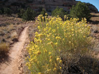
 Water is a scarce commodity in Canyonlands National Park, which has a measly annual precipitation of just seven to ten inches. Consequently any spring or seep is essential to the survival of wildlife, and that’s what makes a walk on the Neck Spring Trail so special. Springs and seeps of water are what this trail is all about, and in the springtime it comes alive with wildflowers. Water is a scarce commodity in Canyonlands National Park, which has a measly annual precipitation of just seven to ten inches. Consequently any spring or seep is essential to the survival of wildlife, and that’s what makes a walk on the Neck Spring Trail so special. Springs and seeps of water are what this trail is all about, and in the springtime it comes alive with wildflowers.
The Canyonlands National Park system encompasses 527 square miles of canyons, mesas, buttes, fins, arches and spires in the heart of the Colorado Plateau, which is segmented into three distinct areas – Island In the Sky (north), The Needles (south) and The Maze (west). The powerful waters within the Green and Colorado Rivers have carved out two large canyons that are major barriers between these three sections of the park.
Island In The Sky is aptly named: On a beautiful autumn day in early October, I can see for miles and miles and miles over vast distances of wide-open, uninhabited land. This far-reaching landscape, with its oddly shaped rock formations, makes me feel like a visitor on a strange planet. Before park status, few except Native Americans, cowboys, river explorers and uranium prospectors entered this rugged and remote corner of southeast Utah. Even today the majority of the park is a wild, untamed territory where big horn sheep, coyote, deer, and kit fox have enough undisturbed space to freely roam. No other place on this earth boasts comparable scenery.
 The Neck Spring Trail makes a 5.8-mile loop, which is a novelty in this district of the park. Most trails are either one-way or a shuttle from road to road. With good footing most of the way, it winds through a wide variety of desert habitat that offers panoramic views of the park and beyond clear over to the Henry and La Sal Mountains. Descending into the upper portions of Taylor Canyon, the trail ambles by two important springs at the base of Navajo sandstone. Before this area became a national park in 1964, the life of the cowboy revolved around the availability of water at Neck and Cabin Springs, but don’t expect large amounts of it. Cabin Spring usually has more water than Neck Spring; neither, however, produces more than a slow trickle. The Neck Spring Trail makes a 5.8-mile loop, which is a novelty in this district of the park. Most trails are either one-way or a shuttle from road to road. With good footing most of the way, it winds through a wide variety of desert habitat that offers panoramic views of the park and beyond clear over to the Henry and La Sal Mountains. Descending into the upper portions of Taylor Canyon, the trail ambles by two important springs at the base of Navajo sandstone. Before this area became a national park in 1964, the life of the cowboy revolved around the availability of water at Neck and Cabin Springs, but don’t expect large amounts of it. Cabin Spring usually has more water than Neck Spring; neither, however, produces more than a slow trickle.
To get to Island In The Sky, drive ten miles north out of Moab on Highway 191 and turn left on Highway 313. Then proceed another 25 miles to the park’s entrance station. The trailhead for Neck Spring is at the first parking area on the left (the Shafer Canyon Overlook), not far beyond the entrance to the park.
 The loop starts and finishes at “The Neck,” a narrow plateau that the highway crosses over. This natural lay of the land allowed early ranchers to control the entire 43 square mile mesa with just one 40-foot fence. Of course, erosion is at work here with the possibility that some day Island In The Sky might really turn into a desert island. The loop starts and finishes at “The Neck,” a narrow plateau that the highway crosses over. This natural lay of the land allowed early ranchers to control the entire 43 square mile mesa with just one 40-foot fence. Of course, erosion is at work here with the possibility that some day Island In The Sky might really turn into a desert island.
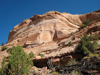
By taking the trail counterclockwise I immediately cross the main road to proceed a short distance along the upper rim of Taylor Canyon, which is actually an old ranchers road. Rock cairns show the way over slickrock, sand and dirt; it follows the mesa top a short distance before dropping down into Taylor Canyon, where The Neck guardrail comes into sight along with the canyon panoramas. For the next mile the undulating trail meanders along the base of Navajo sandstone until I arrive at Neck Spring and the large alcove that contains it. Water, then, is the key for the sudden change in vegetation from blackbrush, prickly pear cactus, yucca and Mormon tea to the thick growth of Gambel’s oak, maidenhair fern and other water loving plants, which are a magnet for the birds, deer and other wildlife who frequent the area. You can walk ten feet off the trail to a downtrodden wooden watering trough that after years of abandonment still stands as a ranching legacy.
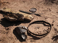 After Neck Spring the trail climbs slightly. The mammoth size of distant rock pillars constantly catches my attention as I traipse along the next two miles to Cabin Spring, the second major spring in the area. Again, it doesn’t take much water to bring forth a green belt lush with the thickness of oaks, pinyons, junipers, and Fremont’s mahonia. I am also witnessing the ranching remnants of a broken fence, a pile of cut logs (possibly from an old cabin), a rock wall and a small iron tank 100 feet below the trail. Inside the metal containment of the dilapidated watering trough, enough dirt and moisture has collected to give life to grasses, moss and various other plants. After Neck Spring the trail climbs slightly. The mammoth size of distant rock pillars constantly catches my attention as I traipse along the next two miles to Cabin Spring, the second major spring in the area. Again, it doesn’t take much water to bring forth a green belt lush with the thickness of oaks, pinyons, junipers, and Fremont’s mahonia. I am also witnessing the ranching remnants of a broken fence, a pile of cut logs (possibly from an old cabin), a rock wall and a small iron tank 100 feet below the trail. Inside the metal containment of the dilapidated watering trough, enough dirt and moisture has collected to give life to grasses, moss and various other plants.
The sky is a heavenly blue on this feeling fallish day. As I walk around I love that crackly crunch of leaves under my feet, and checking out this Garden of Eden, I savor it all - the rabbitbrush flocked with golden yellow blooms, the oaks that show a passion for the scarlet flames of red and the single leaf ash softly displaying its pale yellow leaves.
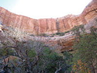
Inside this mini canyon that encases Cabin Spring I am protected from the sharp edges of a brisk breeze and I kick back, relishing the comforting warmth of the sun. In summer it would be a sure bet that I’d be heading for the deep cooling recesses underneath the alcove. The shaggy bark of the huge juniper log I’m resting against makes a wonderful cushion. I relax and listen to the background voices of a white-breasted nuthatch and a scrub jay. They are also attracted to this bountiful oasis that I am reluctant to leave.
After crossing the Cabin Spring drainage, the trail takes an abrupt right, and a twisty ascent begins as I wander by pinyons, junipers and other significant wet spots enriched with cottonwood trees. Then it’s the sudden 300-foot scramble up the slickrock, which is definitely a scramble; the cairns mark the best route up the ledges until finally I top out on level ground. Now the walking is easy again as I head south across Gray’s Pasture, a grassy bench once used for cattle grazing, and I find myself directly above Cabin and Neck Springs. I pass by yet another watering trough before crossing the main road to stroll the paralleling last half-mile old dirt road back to the parking area.
The Neck Spring Trail doesn’t involve a huge commitment of time and can easily be done in half a day. Making the loop adds the extra bonus of discovering something new every step of the way on a trail with a character all its own. Precious pockets of water, a wide variety of habitat from the very dry to the very wet, together with the historical aura of the cowboy era, make it a distinctly different hiking experience.
|
Biological Soil Crust (aka)
Cryptos (krip’ tose):
The surface of
Moab’s desert is held
together by a thin skin of living organisms known as cryptobiotic
soil or cryptos. It has a lumpy black appearance, is very
fragile, and takes decades to heal when it has been damaged.
This soil is a critical part of the survival of the desert.
The cryptobiotic organisms help to stabilize the soil, hold
moisture, and provide protection for germination of the seeds
of other plants. Without it the dry areas of the west would
be much different. Although some disturbance is normal and
helps the soil to capture moisture, excessive disturbance
by hooves, bicycle tires and hiking boots has been shown
to destroy the cryptobiotic organisms and their contribution
to the soil. When you walk around Moab avoid crushing the
cryptos. Stay on trails, walk in washes, hop from stone to
stone. Whatever it takes, don’t crunch the cryptos
unless you absolutely have to! |
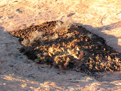
Cryptobiotic soil garden
|
|
|