HIKING HAPPENINGS
October 2008
The Dry Fork – Up To The Tundra
by Marcia Hafner
The timing is perfect: mid-summer-early fall, that’s when the urge hits to go up past the tree line to witness the hardiness and beauty of the tundra wildflowers. The Dry Fork-Beaver Basin Trail delivers. It gets you into the take-your-breath-away high tundra above 10,000 feet. The entire five-mile route begins at Warner Lake -- where the elevation is already 9200 feet -- and goes in an 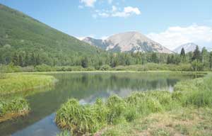 easterly direction all the way to Beaver Basin. Towards the end of the trail, a series of brutally steep switchbacks wind their way up to a pass above Beaver Basin. If you don’t have the energy, time or desire to do that final upward thrust, it’s possible to turn back before you get to it and still feel satisfied with a long walk through an alpine setting. easterly direction all the way to Beaver Basin. Towards the end of the trail, a series of brutally steep switchbacks wind their way up to a pass above Beaver Basin. If you don’t have the energy, time or desire to do that final upward thrust, it’s possible to turn back before you get to it and still feel satisfied with a long walk through an alpine setting.
It takes about an hour to drive the 35 miles (that’s an educated guess) to Warner Lake. To get there from Moab, go south on Highway 191 for approximately eight miles. Then turn left at the Ken’s Lake - La Sal Loop Road sign. Take a right at the dead-end, which becomes the La Sal Loop Road. Go past the turn offs for Geyser Pass Road and Oowah Lake. The next major road on your right after Oowah will have a sign for Warner Lake. This five-mile graveled road is suitable for any vehicle, but is only open during the summer-early fall season. By late September-early October the possibility exists that the road will be closed for the winter. Near the lake are a picnic area, a campground with twenty tent sites, and a group campsite that accommodates fifty people. For the frivolous get away, a small cabin is available, which includes the luxury of a shower.
A relaxing afternoon can easily be spent at Warner Lake, where fishing for rainbow trout is a popular activity. It’s also a good place to watch the birds. Ring-necked ducks with their young can often be seen making power dives, while violet-green swallows zoom over the water’s edge. I am equally intrigued with the miniature helicopters of the bug world – dragonflies that hover in their own flight zone just above the waterline.
The trail starts on an old faded road that goes beyond the lake before it crosses over a diversion ditch and a culvert. That is followed in quick sequence by an easy stream crossing, a short ascent, two gates to open and close and a cautious walk over a cattle guard. Almost imperceptibly the road then becomes a trail, and back down it goes into the upper Mill Creek drainage; be prepared for a tricky leapfrog stream crossing from one slippery rock to another.
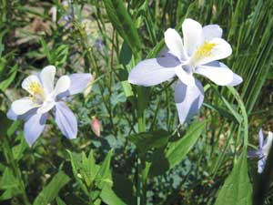 At the fork in the trail, a big decision must be made – left for the Dry Fork of Mill Creek or right for Burro Pass and the headwaters of Mill Creek? If you want to keep your feet dry, go left. Don’t, however, let the name Dry Fork deceive you. There’s no gushing flow of water except during the spring run off, but this trail is anything but dry. The abundance of snowmelt nourishes a profuse production of wildflowers - red columbines, bluebells, purple fringe, blue flax, Jacob’s ladder, showy daisies, scarlet gilia and my favorite – blue columbine. There’s also a big supply of mint and that delightful scent often fills the air. At the fork in the trail, a big decision must be made – left for the Dry Fork of Mill Creek or right for Burro Pass and the headwaters of Mill Creek? If you want to keep your feet dry, go left. Don’t, however, let the name Dry Fork deceive you. There’s no gushing flow of water except during the spring run off, but this trail is anything but dry. The abundance of snowmelt nourishes a profuse production of wildflowers - red columbines, bluebells, purple fringe, blue flax, Jacob’s ladder, showy daisies, scarlet gilia and my favorite – blue columbine. There’s also a big supply of mint and that delightful scent often fills the air.
Muddy areas on the trail attract the butterflies – Milbert’s tortoiseshells, painted ladies, brown butterflies, white butterflies and tiny blue butterflies. The males, in particular, congregate on damp sand or soil to imbibe salts and water, and that is referred to as “mud puddling.” The salts are passed on to the female during mating to contribute to the nourishment of the eggs. So intent are they in their nutrient cocktail feast, a close up, even touchable approach is possible. Another amazing insect phenomenon, not far from the butterfly frenzy, is aphids being attended by ants.
One reason I like this trail so much is because it wanders through thick groves of aspens. Each grove originated from a single organism. Keeping it all in the family, they clone themselves by sending out roots and runners across an entire open area. By sprouting up at the same time from a single root system, they are identical in size and act as one organism, with their own timetable for leafing out in the spring. In the fall each golden grove changes into its own identical color code that differs slightly from its neighbors, with some even showing a reddish tint.
The distinctive eye-shaped formations on the trunks of aspens are the result of self-pruning. During its growth, each tree cuts off the sap to the lower branches, which atrophy and fall off, leaving those distinctive scars. Aspen bark is very sensitive, and once damaged it is marked for the rest of its life. Many stories are told in the bark of an aspen -- from the nibbling of an elk, or the claw marks of a bear to heart shaped carvings of romantic lovers and historical recordings of the cowboys and sheepherders who roamed the area many years ago.
In the final segment of the Dry Fork Basin, massive Engelmann Spruce dominate the trail and their tall, wide girths shut out the sun, producing a dark, damp atmosphere where even in early August patches of snow may still linger. Now sections of the trail fade away making it hard to follow as it weaves in and out of the trees, but the visibility of the pass sandwiched in between Manns Peak and Mount Waas can be a useful guide. Eventually a rock cairn points the way to the beginning of the switchbacks up the rocky slope to a different world of rarified air where only the strongest of stunted vegetation and flowers, such as moss campion, alpine primrose, alpine sandwort, alpine spring beauty and alpine sunflowers can withstand this bitter cold atmosphere. Clinging very close to the protection of the ground guarantees their survival.
Finally after the heart pounding work out to get to the pass, you can savor the high of breathless tundra views on top of the pass, and the relief that it’s downhill all the way back to Warner Lake!
|
Biological Soil Crust (aka)
Cryptos (krip’ tose):
The surface of
Moab’s desert is held
together by a thin skin of living organisms known as cryptobiotic
soil or cryptos. It has a lumpy black appearance, is very
fragile, and takes decades to heal when it has been damaged.
This soil is a critical part of the survival of the desert.
The cryptobiotic organisms help to stabilize the soil, hold
moisture, and provide protection for germination of the seeds
of other plants. Without it the dry areas of the west would
be much different. Although some disturbance is normal and
helps the soil to capture moisture, excessive disturbance
by hooves, bicycle tires and hiking boots has been shown
to destroy the cryptobiotic organisms and their contribution
to the soil. When you walk around Moab avoid crushing the
cryptos. Stay on trails, walk in washes, hop from stone to
stone. Whatever it takes, don’t crunch the cryptos
unless you absolutely have to! |
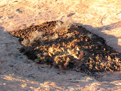
Cryptobiotic soil garden
|
|
|