HIKING HAPPENINGS
June 2007
The Portal Overlook
-
My Favorite View Of Town
by Marcia Hafner
 The
first time I walked up the Portal Overlook Trail, the steady,
uphill grind that I encountered on that steep trail felt
like the longest one and a half miles I had walked in a long
time. Not realizing then that it gained 1000 feet in elevation,
it was not the easy, short duration walk I had anticipated.
After that introduction, I now know what to expect and the
more I walk this trail, the easier it gets. I return to it
often because I enjoy the work-out to the overlook with the
reward of the breathtaking (mainly because I’m breathing
so hard) panoramic view. The
first time I walked up the Portal Overlook Trail, the steady,
uphill grind that I encountered on that steep trail felt
like the longest one and a half miles I had walked in a long
time. Not realizing then that it gained 1000 feet in elevation,
it was not the easy, short duration walk I had anticipated.
After that introduction, I now know what to expect and the
more I walk this trail, the easier it gets. I return to it
often because I enjoy the work-out to the overlook with the
reward of the breathtaking (mainly because I’m breathing
so hard) panoramic view.
After a short pause, I start a full circle with my binoculars
beginning in a northerly direction for a distant look at
the Bookcliffs on the other side of I-70. To the northeast
I gaze at the stunning landmarks of Balanced Rock and the
arches in the Windows section of Arches National Park. Across
the river cor-ridor, I can faintly see Castle Rock protruding
up from a v-shaped dip on the Porcupine Rim. So dominant
on the eastern horizon, the impressive La Sal Mountain Range,
snow covered most of the year, is an overpowering eye catcher.
Then I let my vision drift south and southwest to the Moab
Rim and the warped red sandstone contortions of Behind The
Rocks that includes a background view of the Abajo Mountains.
Finally directly behind me are the towering domes of the
Portal formation.
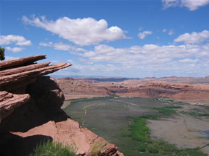 The
thing I especially like about the Portal Overlook is
the view of town, the Scott M. Matheson Preserve and
the wide sweep of the Colorado River which are directly
below my observation point. I spend a lot of time picking
out familiar landmarks in the preserve and the many
of the businesses that line highway 191. I’m
also watchful for year-round birds such as ravens,
golden eagles and red-tailed hawks that take advantage
of the thermals along the rim. Mid-spring through early
fall violet-green swallows and the white-throated swifts
also follow this aerial route with the speed-demon
swifts sometimes whizzing by so close, they give me
a buzz. The
thing I especially like about the Portal Overlook is
the view of town, the Scott M. Matheson Preserve and
the wide sweep of the Colorado River which are directly
below my observation point. I spend a lot of time picking
out familiar landmarks in the preserve and the many
of the businesses that line highway 191. I’m
also watchful for year-round birds such as ravens,
golden eagles and red-tailed hawks that take advantage
of the thermals along the rim. Mid-spring through early
fall violet-green swallows and the white-throated swifts
also follow this aerial route with the speed-demon
swifts sometimes whizzing by so close, they give me
a buzz.
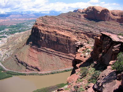
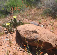
The flow of the Colorado River is squeezed between the sandstone
domes on the north and south side of the river and this feature
is referred to as The Portal. This is a well-used trail mainly
on slickrock of the Kayenta formation that wraps around the
face of The Portal on the north side of the river. During
the first part of the trail, the river stays in view. When
I get to a spot that I refer to as “The Hump,” I
get my first glimpse of town. This is when the river goes
out of the bounds of my vision and I can now see the domes
above the Portal Overlook. My goal is now within sight and
that gives me an extra boost. When I get to the final switchbacks
that go from one ledge to another, I know so well that I
am almost there.
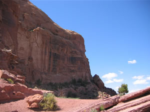 There
is no sign at The Overlook and walking further on this north
facing part of the trail can be hazardous. A hiker should
tread with caution particularly in winter. Just one little
slip, a loss of balance and it’s at least a several
hundred foot drop off the edge. This trail continues on to
the Poison Spider Mesa and is frequently used by mountain
bikers usually going down to make a loop ride from the Poison
Spider Trailhead. There
is no sign at The Overlook and walking further on this north
facing part of the trail can be hazardous. A hiker should
tread with caution particularly in winter. Just one little
slip, a loss of balance and it’s at least a several
hundred foot drop off the edge. This trail continues on to
the Poison Spider Mesa and is frequently used by mountain
bikers usually going down to make a loop ride from the Poison
Spider Trailhead.
Because the trail up to the viewpoint is south facing, snow
melts off quickly making it an easy year round walk but in
my opinion, it is at its best in the spring. With its southern
exposure the rocks retain their heat and that gives the wildflowers
an early boost. By the end of February I often savor the
first wildflowers of the season; the tiny yellow blooms of
the Newbury twinpod.
As
the spring season progresses, so do the flowers. Look for
the tubular, pinkish-red Eaton’s pentstemon, the yellows
of the holly-like Fremont’s mahonia, the elongated
yellow stalks of the Prince’s Plume, the pale-pink
rockcress, the flaming orange of the globemallow and the
purple scorpionweed named for its habit of 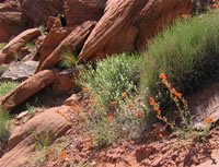 curling
up like the tail of a scorpion. The final hurrah before the
scorching summer heat shuts the desert flowers down is in
May and early June when the prickly pear cactus puts on a
burst of varying shades of yellow. A spring time walk up
the Portal Trail is also filled with song as I tune into
the trills of the rock wren and the cascading, bubbling cadence
of the canyon wren. curling
up like the tail of a scorpion. The final hurrah before the
scorching summer heat shuts the desert flowers down is in
May and early June when the prickly pear cactus puts on a
burst of varying shades of yellow. A spring time walk up
the Portal Trail is also filled with song as I tune into
the trills of the rock wren and the cascading, bubbling cadence
of the canyon wren.
The
big drawback of a southern exposure is the scarcity of shade
in the summer during most of the day and the sizzling heat
makes the rocks untouchable. My advice to summertime hikers
who want to use this trail is to start very early in the
morning or wait until very late in the afternoon.
 Going
on an outing to the Portal Overlook is not a huge commitment
of time. From Moab, it’s just a few minutes drive.
The hike can easily be done round trip in two to three hours.
So if you are pressed for time and can spare just a morning
or afternoon, this trail would be a good choice. Going
on an outing to the Portal Overlook is not a huge commitment
of time. From Moab, it’s just a few minutes drive.
The hike can easily be done round trip in two to three hours.
So if you are pressed for time and can spare just a morning
or afternoon, this trail would be a good choice.
[To get to the Portal
Overlook Trail from town, drive north on Main St. (Highway
191). After crossing the Colorado River, take a left turn
on to Utah 279 (the Potash Rd.) Go down river for 4.2 miles
and park at the Jay Cee Park Recreation Site. The trailhead
is here and a sign gives a description of the trail.]
|
Biological
Soil Crust (aka)
Cryptos (krip’ tose):
The surface of
Moab’s desert is held together by a thin
skin of living organisms known as cryptobiotic
soil or cryptos. It has a lumpy black appearance,
is very fragile, and takes decades to heal when
it has been damaged. This soil is a critical part
of the survival of the desert. The cryptobiotic
organisms help to stabilize the soil, hold moisture,
and provide protection for germination of the seeds
of other plants. Without it the dry areas of the
west would be much different. Although some disturbance
is normal and helps the soil to capture moisture,
excessive disturbance by hooves, bicycle tires
and hiking boots has been shown to destroy the
cryptobiotic organisms and their contribution to
the soil. When you walk around Moab avoid crushing
the cryptos. Stay on trails, walk in washes, hop
from stone to stone. Whatever it takes, don’t
crunch the cryptos unless you absolutely have to! |
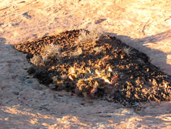
Cryptobiotic soil
garden
|
|
|