Moab
UT (at City Hall)
38O34’ N Latitude 109O33’ W Longitude
4048 ft - 1234 m |
DARK SKY HAPPENINGS - March 2018
Moab Dark Skies mission is to promote the appreciation and conservation of Moab’s valuable and rare dark skies. The Moab Dark Skies was established by the Friends of Arches and Canyonlands Parks in conjunction with the National Park Service and Utah State Parks Division of Natural Resources.
Public Utah Lighting Inventory Findings
By Adam Dalton and Nathan Jellen
Sunrise-Sunset
for March
(The time of sunrise and sunset assumes a flat horizon. Actual time may vary depending upon the landscape.) |
DATE |
SUNRISE |
SUNSET |
1 |
6:32 am |
5:52 pm |
2 |
6:31 am |
5:53 pm |
3 |
6:29 am |
5:54 pm |
4 |
6:28 am |
5:55 pm |
5 |
6:26 am |
5:56 pm |
6 |
6:25 am |
5:57 pm |
7 |
6:23 am |
5:58 pm |
8 |
6:22 am |
5:59 pm |
9 |
6:20 am |
6:00 pm |
10 |
6:19 am |
6:01 pm |
11* |
7:17 am |
7:02 pm |
12 |
7:16 am |
7:03 pm |
13 |
7:14 am |
7:04 pm |
14 |
7:12 am |
7:05 pm |
15 |
7:11 am |
7:06 pm |
16 |
7:09 am |
7:07 pm |
17 |
7:08 am |
7:09 pm |
18 |
7:06 am |
7:10 pm |
19 |
7:04 am |
7:11 pm |
20 |
7:03 am |
7:12 pm |
21 |
7:01 am |
7:13 pm |
22 |
7:00 am |
7:14 pm |
23 |
6:58 am |
7:15 pm |
24 |
6:56 am |
7:16 pm |
25 |
6:55 am |
7:17 pm |
26 |
6:53 am |
7:18 pm |
27 |
6:52 am |
7:19 pm |
28 |
6:50 am |
7:20 pm |
29 |
6:48 am |
7:21 pm |
30 |
6:47 am |
7:22 pm |
31 |
6:45 am |
7:23 pm |
*Note: hours shift because clocks change forward 1 hour. |
|
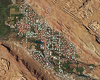 |
Moab’s Lighting: Here, the city’s exterior lighting stock is shown by location and distinguished by fixture shielding. Green dots represent fully-shielded lighting, at minimal risk for causing light trespass. Orange dots represent partially-shielded lighting fixtures, and red dots depict unshielded lights, which cause unmitigated light trespass. |
In June-July 2017, University of Utah graduate students Adam Dalton and Nathan Jellen conducted an inventory of publicly-owned lights belonging to the city of Moab and Grand County in cooperation with the Moab Dark Skies Group, city and county government, and the University of Utah’s Consortium for Dark Sky Studies. The project’s aim was to establish a lighting baseline in the city and county to inform the implementation of dark sky-friendly lighting ordinances.
Over the two-month period, Dalton and Jellen walked along every street in Spanish Valley—
a fun yet repetitive task—and visited each fixture twice, once during the day and once at night, to take photos and identify the following metrics:
• Fixture location
• Fixture height
• Fixture purpose (roadway, sign, parking lot, etc.)
• Fixture type (lamp post, bollard, wall sconce, etc.)
• Lamp type (LED, metal halide, high pressure sodium, etc.)
• Fixture power source (utility, solar)
• Adaptive controls (motion sensors, switch, photocell, timer, etc.)
• Fixture shielding
• Correlated color temperature (the color appearance of the light)
• Illuminance (a measure of brightness)
• Footcandles (a measure of the intensity of light as it falls on a surface, like a road)
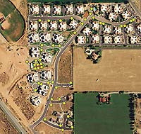 |
| Rim Village Lighting: Grand County’s Rim Village subdivision is a local example of best practices in dark sky-friendly lighting. |
In total, Dalton and Jellen inventoried 2,102 light fixtures in Moab and Grand County. Of these, 986 lights belong to Moab City; 697 were on at night. Additionally, 753 lights belong to Grand County, of which 371 were on at night. The remaining 363 lights inventoried belong to federal agencies (post office, national parks, etc.) and select business entities in the area (hotels, restaurants and bars, grocery stores, gas stations). Undertaking this lighting inventory, one of the first comprehensive lighting inventories of any U.S. municipality and county, was an incredible experience. Dalton and Jellen are truly grateful to the amazing people they met and look forward to providing future input regarding lighting in the area.
17 - Star Party at Dead Horse Point State Park
Join rangers from Dead Horse Point, Arches and Canyonlands National Parks for a celebration of southern Utah’s dark skies! Party will include a brief program, constellation tour & telescope viewing. Meet at the Dead Horse Point Visitor Center around 7:45pm & expect the program to last until 9:00pm. Bring camp chairs to sit on, red lights to walk around, warm clothes for chilly conditions & a desire to discover! Park entrance fee required.
March 31 - Full Moon Hike at Dead Horse Point State Park
Join a ranger for a hike under the light of the full moon. Arrive around 7:30pm & expect an hour long hike over easy terrain. Bring a headlamp or flashlight (but don’t expect to use it), warm clothes for chilly conditions & sturdy hiking footwear. Hike meets at the Visitor Center & will travel a portion of the East Rim Trail. Park entrance fee required.
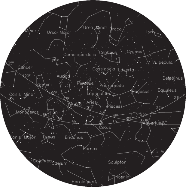
Note: Hold the star chart high above your head and match the compass directions to the direction you are facing. Adjust the star chart by orienting Ursa Major (Big Dipper) to match its position in the sky and pull the edges down to create a dome.
The star chart approximates the sky from astronomical twilight to midnight. As the night and month progresses, the constellations shift toward the northwest. The celestial equator is measured in hours (h).
The ecliptic is measured in degrees.
|